

When the weather is good, there is so much to do outdoors in Ireland – solo, or with family or friends. Here are seven activities - with locations, descriptions, tips and some maps for a general guide.
Below you can read John O'Dwyer's pick for a great walking path, Conor O'Keeffe on a running route, Rozanna Purcell recommends a hiking trail, Mary McCarthy on an outdoor swimming location, Ian O'Riordan picks a cycle trip, Sylvia Thompson on a family-friendly park and Fiona Alston selects a popular outdoor gym.
And remember, whatever you do and wherever you go, please be safe. And enjoy.
Name Old Rail Trail
Distance 13km, linear trail
Approximate duration 3 hours
Difficulty Easy
Starting point Google Maps Beechpark, Garrycastle, Athlone (grid reference N 046 419); you can follow this Westmeath Co Council guide
Amenities Athlone and Moate
One of Ireland's lesser-known greenways, the Old Rail Trail runs 44.5km, linking Athlone to Mullingar. A great outing is to walk the 13km from Athlone to Moate and enjoy a picnic lunch. Then either walk or get a taxi back.
Name: Mullaghmeen Forest (White Loop)
Difficulty: Moderate
Length: 8km
Format: Loop
Dogs: Allowed under effective control
Footwear: Road or Trail Runners
Background: Mullaghmeen in north Westmeath is the largest planted beech forest in Ireland. This 1,000 acre forest has an extensive network of way marked trails for varying levels of fitness.
Mullaghmeen is located approximately 8km west of Oldcastle, Co Meath and is an isolated area of forest rising above the farm land of north Westmeath. Mullaghmeen Forest is the largest planted beech forest in Ireland. Along with beech, Mullaghmeen also has Sitka spruce, Scots pine and noble fir and a very interesting native tree collection. This 1,000 acre forest offers picnickers a shady haven in which to feast and provides the more energetic with scenic walks of varying length. The Red Trail takes you to the summit of Mullaghmeen and provides magnificent views north across Lough Sheelin and into the neighbouring county of Cavan.
The forest, once an out farm belonging to a Lord Gradwell, has many examples of man's former impacts on the landscape. Following the White Trail (one of the walking trails) one passes sad reminders of famine times with relic walls of famine fields. A Booley Hut, a summer grazing shelter, is just off the Red Trail, while the Flax Pits show that this important crop for the linen industry was once harvested and cured in this area. The underlying geology is limestone rock and in the south-eastern corner more of its geology is revealed where one can see turloughs: disappearing lakes that fill and empty with no apparent in or outflow. Come in spring for the best displays of woodland flowers notably bluebells. The area is populated with grey squirrels, jays, badgers, foxes, pheasant, rabbit and hares, as well as a large selection of song birds. (Aided by: Sport Ireland and Coillte)
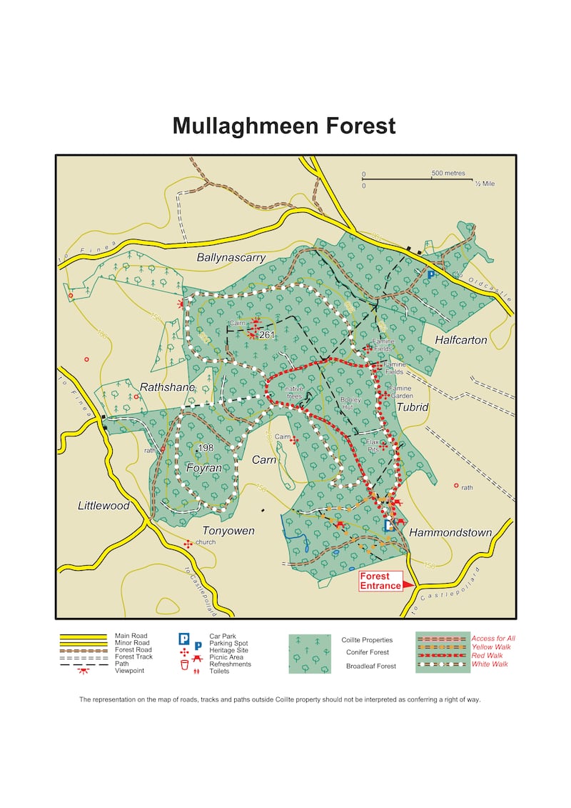
Hike name Mullaghmeen Forest East Loop
Distance 4km
Elevation gain 130m
Approximate duration 1 hour
Difficulty Beginner
Route type Loop
Starting point See AllTrails Mullaghmeen Forest East Loop
Amenities Parking, picnic tables
Dog-friendly? Yes
Tips You can add distance on to this trail and join others and looping back. Take a picture of the area route maps before setting off to build your own routes
Name: The Cut
Location: Google Map: Lough Lene, Co Westmeath
Brief description: A small beach on the freshwater lake of Lough Lene. Public access is on the eastern shore, near Collinstown
Amenities: Toilets, car park (opposite side of road)
Lifeguard: No
Water quality: Excellent – sampled Westmeath County Council September 2020
Tips: A boardwalk with ladders brings you into your depth. The bathing area is 70m by 170m and never too packed as can accommodate 100 swimmers ; quite shallow so no diving.
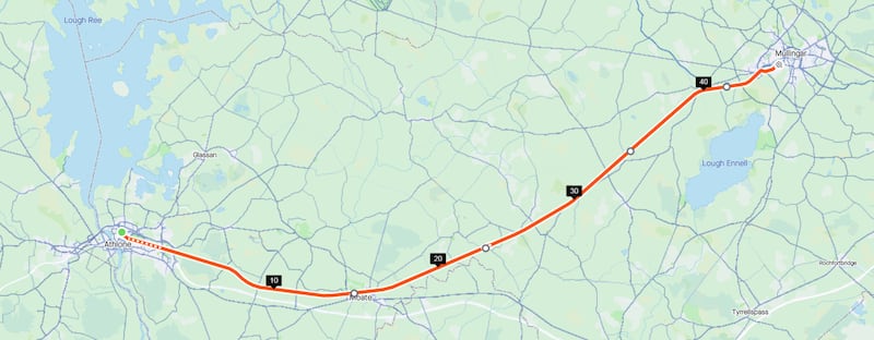
Name: The Old Rail Trail
Start location: Athlone
Route: Purpose built off-road pedestrian and cycleway trail, along disused railway track, via Moate, Streamstown and Castletown Station on the way to Mullingar.
Distance: 40km
Time: 2-3 hours
Highlights: Perfect for cycling families given easy access and safe route.
Look out for: The old abandoned railway stations along the way.
Tips: Though entirely off-road care is needed at the road junctions.
Park name: Belvedere House, Gardens and Park, Mullingar
Amenities: Plenty of lovely walks through woodlands, along the shores of Lough Ennell and Belvedere Lake. Four children's play areas, one of which includes a 30 metre zip line.
Special features: The Victorian walled garden has a special dedicated fairy garden.
Access: Free car and bicycle parking. Adults €6.40, child 4-16 €3.20. Google Map "Belvedere House, Westmeath".
Dogs: Dogs on leads welcome.
Tip: Check to see if Belvedere House is open for tours on the day of your visit.
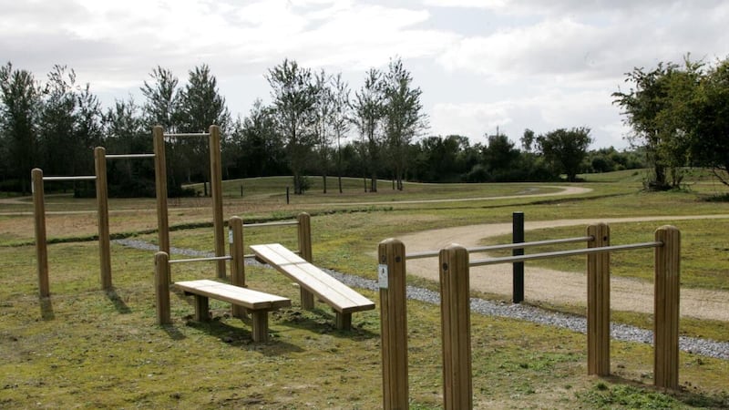
Name: Athlone Fitness Park
Equipment: A selection of wooden bodyweight exercise stations around the park, including pull-up bars, abs station, balance beams and triceps dips.
Location: Google Maps
Information: The fitness park also has a 2.5km trail loop, a 1.5km tarmac loop, kids' outdoor equipment, pedal karting and a sensory garden.
Get Active Series
- 32 great walking routes in Ireland - one in each county
- 32 great hikes in Ireland
- 32 great running routes
- 32 great outdoor swim locations
- 32 great cycling routes
- 32 great parks
- 32 great outdoor gyms


