

When the weather is good, there is so much to do outdoors in Ireland – solo, or with family or friends. Here are seven activities - with locations, descriptions, tips and some maps for a general guide.
Below you can read John O'Dwyer's pick for a great walking path, Conor O'Keeffe on a running route, Rozanna Purcell recommends a hiking trail, Mary McCarthy on an outdoor swimming location, Ian O'Riordan picks a cycle trip, Sylvia Thompson on a family-friendly park and Fiona Alston selects a popular outdoor gym.
And remember, whatever you do and wherever you go, please be safe. And enjoy.
Name Nore Valley Walk
Distance 11km linear trail
Approximate duration 2.5 hours
Difficulty Easy
Starting point Google Maps Bennettsbridge (grid reference S 552 492)
Amenities Bennettsbridge and Kilkenny
Rewarding outing following the serene Nore upriver to pass many relics from Kilkenny's industrial heritage. The finish is beside the great Norman castle at the heart of the Marble City.

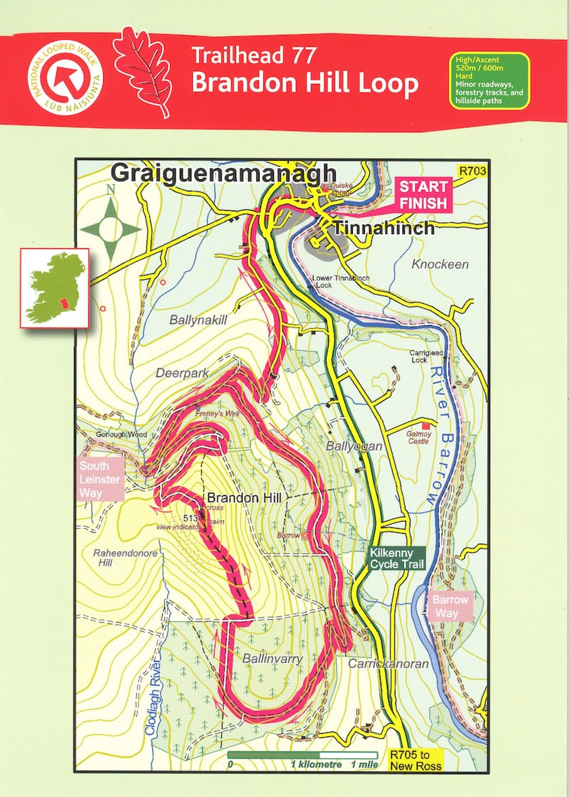
Name: Brandon Hill Loop – Trailhead Graiguenamanagh
Distance: 19km
Elevation: 520m/600m
Difficulty: Moderate to hard
Terrain: Minor roadways, forestry tracks and hillside paths
Footwear: Road or Trail Runners
Directions to Trailhead: Brandon Hill loop starts in the town of Graiguenamanagh. The trailhead is at the Barrow Valley Activities Hub located on the River Barrow. Turn right immediately before the bridge.
Route Information: Starting from the trailhead, follow the purple arrows turning left at the bridge and immediately left again. You are also following the yellow arrows of the South Leinster Way. Turn left again, run 500m to a cul-de-sac at the side of the town bypass. Cross the road to join a minor road. Follow this road for 200m to reach a junction with another minor road on your left. Turn left here. Follow this road for almost 2km where it merges into a forestry roadway – still following the purple and yellow arrows. After 200m the forestry track turns a right bend and passes through a barrier into Gorlough Wood. 300m later you reach a three-way junction where the South Leinster Way continues straight, but you turn left.
Continue to follow purple arrows along a forestry track for 3km to reach another three-way junction where the loop veers right. Ascend along the forestry track as it zig-zags and then skirts around Ballinvarry Hill. After nearly 2km, you reach a crossroads of tracks where the loop turns sharp right onto a “green” roadway and starts the ascent toward Brandon Hill. After 500m of a climb, you reach a concrete stile and join a track where you turn right along the top of forestry and open hillside on your left. Pay close attention now because less than 200m later you will turn left again and join a path on the hillside which will take you to the top of Brandon Hill.
From the top, look for a waymarker which points you onto a stony path which marks the start of your inward journey. The path zig-zags and descends downhill to reach the edge of forestry where you veer right on to a forestry road. After nearly 1km you reach a Y-junction where the loop rejoins the South Leinster Way. Veer right and start to descend again into Gorlough Wood – following the purple and yellow arrows. Pass by the site of Reneys Well to rejoin the three-way junction where you started the loop. This time, proceed straight and follow the purple (and yellow) arrows back to the town of Graiguenamanagh. (Aided by: Coillte)
Hike name Brandon Hill Loop
Distance 12km
Elevation gain 650m
Approximate duration 3-3.5m
Difficulty Intermediate
Route type Loop
Starting point See AllTrails Brandon Hill
Amenities Parking (limited)
Dog-friendly? No
Tips Bring a map and a good sense of direction, as there isn't much signage
Name: The Weir
Location: Google Map: Bleach Road, Dunmore
Brief description: Popular swimming spot on the River Nore
Amenities: Toilets, parking
Lifeguard: Summer 2pm-4.30pm and 5pm-7.30pm. June weekends only
Water quality: Good status – 2013 - 2018 EPA report
Tips: Decent pier platform for easy access. Water quite deep only suitable for good swimmers
Name: North Kilkenny Cycling Loop
Start location: The Parade, Kilkenny
Route: A most pleasant cycle from Kilkenny City to Jenkinstown Park and to Dunmore Cave along mostly riverside roads and rural laneways.
Distance: 27kmk
Time: 1.5 to 2.5 hours
Highlights: One of the three designated cycle loops out of Kilkenny most suited to the leisure cyclist.
Look out for: The busy stretch of the N78 before turning onto Dunmore Cave laneway.
Tips: For more see visitkilkenny.ie
Park name: Castlecomer Discovery Park, Castlecomer
Amenities: Mapped out walking, mountain biking and orienteering trails scattered throughout this 30 hectare woodland demesne.
Special features: A tree-top walk, high ropes course and zipline over water.
Access: Paid car parking on site. Park entrance free, but charges for activities.Google Map "Castlecomer Discovery Park".
Dogs: Dogs on leads only
Tip: Book ahead and plan your trip, preparing for all weathers.
Name: Nore Linear Park, Kilkenny
Equipment: Steps/box jumps, suspension training, calisthenics gym and weighted dumbbells.
Location: Google Maps
Information: 4km looped walk by the river through meadow and woodland. Swimming when lifeguards on duty.
Get Active Series
- 32 great walking routes in Ireland - one in each county
- 32 great hikes in Ireland
- 32 great running routes
- 32 great outdoor swim locations
- 32 great cycling routes
- 32 great parks
- 32 great outdoor gyms


