

When the weather is good, there is so much to do outdoors in Ireland – solo, or with family or friends. Here are seven activities - with locations, descriptions, tips and some maps for a general guide.
Below you can read John O'Dwyer's pick for a great walking path, Conor O'Keeffe on a running route, Rozanna Purcell recommends a hiking trail, Mary McCarthy on an outdoor swimming location, Ian O'Riordan picks a cycle trip, Sylvia Thompson on a family-friendly park and Fiona Alston selects a popular outdoor gym.
And remember, whatever you do and wherever you go, please be safe. And enjoy.
Name Battle of the Boyne Walk
Distance 5km loop
Approximate duration 1.5 hours
Difficulty Easy
Starting point Google Maps Oldbridge House (grid reference O 041 760)
Amenities Parking, visitor centre and cafe
Unchallenging outing on mostly level terrain that drips with history at virtually every turn. Can be a bit mucky in places, so waterproof footwear is an advantage.

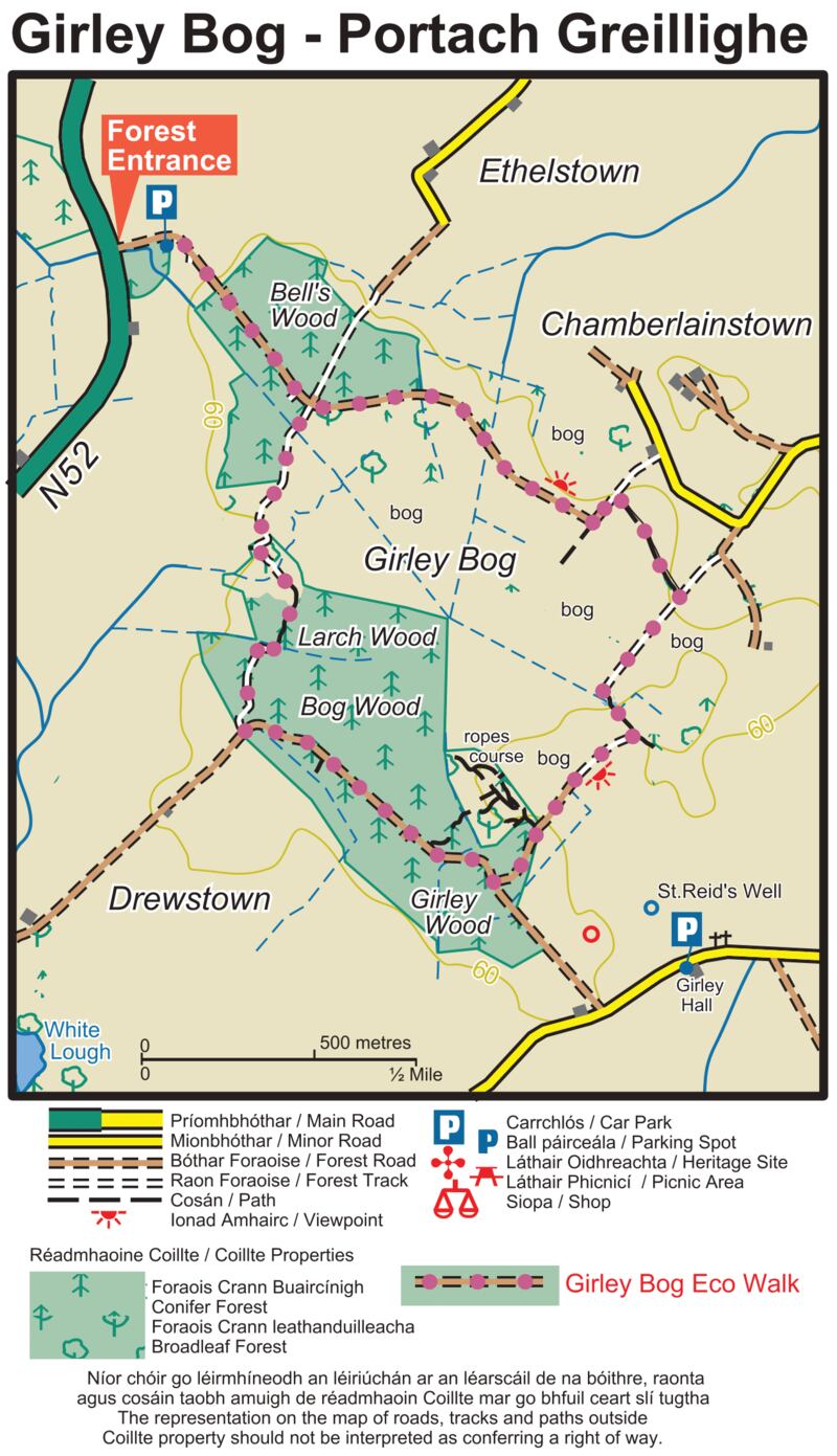
Name: Kells Girley Bog Eco Walk
Ascent: 20m
Distance: 6km
Grade: Moderate
Footwear: Road or Trail Runners
Services: Kells (7.5km)
Terrain: Bog roads, forestry tracks and woodland
Theme: Nature
Trailhead: Drewstown Woods, near Kells, Co Meath
Route information: Girley Bog is a site of considerable conservation significance as it comprises raised bog, a rare habitat in Europe and one that is becoming increasingly scarce and under threat in Ireland. Leaving the trailhead, the trail follows a forestry track for 600 metres to a crossroads from where the loop proper begins. Turn right here. The loop travels another 1km to reach the end of an old bog road. Here it turns left onto a woodland trail. Now the loop passes through deciduous woodland and coniferous forestry to exit onto a forestry roadway. Turn left here.
Follow the forestry roadway for 1km before turning left and joining an access road to bogland. Climb a stile at a gateway and follow a grassy track for 300 metres before turning left, and crossing a short section of bog before joining a bog roadway where you turn right at an interpretive panel. After a short distance the loop turns sharp right and follows a track through a line of trees. Exiting the trees, the loop turns left onto an old bog road again and for the next 2km circles a raised bog area. The loop rejoins the outward section at the crossroads mentioned at B above, where it goes straight and covers the final 600 metres to the trailhead.
Throughout most of history Irish bogs were impassable. To cross the wet, boggy terrain people built bog roads or “toghers”. In the 20th century, as the bogs were exploited for fuel, thousands of important archaeological finds were made, including swords, jewellery, trumpets and human bodies (preserved by the acid nature of the bog). Another interesting use of the bog was to keep butter cool during summer and there have been many finds of butter kept in wooden container called “methers”.
Girley Bog is a site of considerable conservation significance as it comprises raised bog, a rare habitat in Europe and one that is becoming increasingly scarce and under threat in Ireland. The loop covers a variety of landscape of forest and bogland and has been developed as an eco-walk with interpretive panels throughout. The early section traverses coniferous forestry planted on high bog, the trees are fast growing species (sitka spruce and lodgepole pine) that originate in North America. The main element of the loop is within the bogland where there is a wonderful variety of birdlife, plants and animals. (Aided by: Meath.ie)
Hike name Mullaghmeen Forest Loop Walk
Distance 6km
Elevation gain 274m
Approximate duration 1.5-2 hours
Difficulty Beginner
Route type Loop
Starting point See AllTrails Mullaghmeen Forest Loop
Amenities Parking
Dog-friendly Yes
Tips Keep a sharp eye on the trail, as it's easy to go off. Take a picture of the forest map before setting off.

Name: Laytown
Location: Google Map: Laytown beach
Description: Fine sand beach. Decent sized bathing area 1.5km in length and 0.6 km2 in area
Amenities: Toilets, parking
Lifeguard: Summer months
Water quality: Excellent – Meath County Council September 2020
Tips: Great swimming community comes here and there's a good buzz
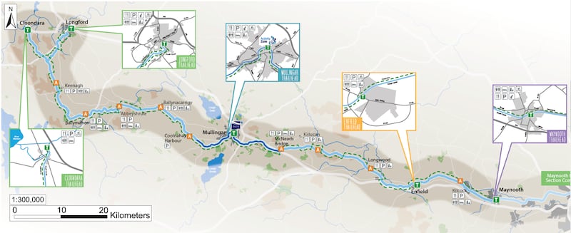
Name: Royal Canal Greenway
Start location: Enfield
Route: Another mostly flat slice of the level towpath from Enfield taking in Longwood, where you can also connect with the Boyne Blueway Trim, as far as Killucan.
Distance: 25km
Time: 1-2 hours
Highlights: A section of the Greenway which over the full 130km includes 90 bridges, 33 locks, 17 harbours and four aqueducts.
Look out for: The Boyne Aqueduct and Boyne Viaduct along the way.
Tips: Remember this is a shared greenway with walkers so be patient and alert.
Park name: Balrath Woods, Burtonstown
Amenities: Nature walks and play equipment including a giant climbing web and accessible swings.
Special features: Signposted long and short walks. The nature walk, which is designed as an outdoor classroom, has information panels along the way.
Access: Car park on site. Google Map "Balrath Woods".
Dogs: Yes.
Tip: Check out balrathwoods.com for descriptions of animals, insects, birds, flowers and trees that you might see when you get there.
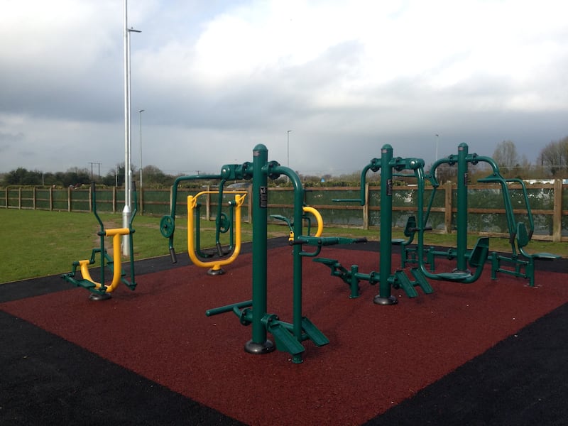
Name: Blackwater Park, Navan
Equipment: Cross trainer, hand cycle, chest press, walker, lat pull-down, stepper, fitness rider.
Location: Google Maps
Information: Walking track, off-road cycle track, kids' adventure play area. Also available on orienteering apps like MapRunF.
Get Active Series
- 32 great walking routes in Ireland - one in each county
- 32 great hikes in Ireland
- 32 great running routes
- 32 great outdoor swim locations
- 32 great cycling routes
- 32 great parks
- 32 great outdoor gyms


