

When the weather is good, there is so much to do outdoors in Ireland – solo, or with family or friends. Here are seven activities - with locations, descriptions, tips and some maps for a general guide.
Below you can read John O'Dwyer's pick for a great walking path, Conor O'Keeffe on a running route, Rozanna Purcell recommends a hiking trail, Mary McCarthy on an outdoor swimming location, Ian O'Riordan picks a cycle trip, Sylvia Thompson on a family-friendly park and Fiona Alston selects a popular outdoor gym.
And remember, whatever you do and wherever you go, please be safe. And enjoy.
Name Peatlands Walk
Distance 10km
Approximate duration 2.5 hours
Difficulty Easy
Starting point Google Maps Peatland Park Visitor Centre carpark (grid reference H 897 603); you can follow this Walk NI guide
Amenities Parking, information centre
Sublime loop walk exploring a profusion of natural habitats, including woodlands, uncut bogs and Derryadd Lough, using a raised boardwalk to circle it.

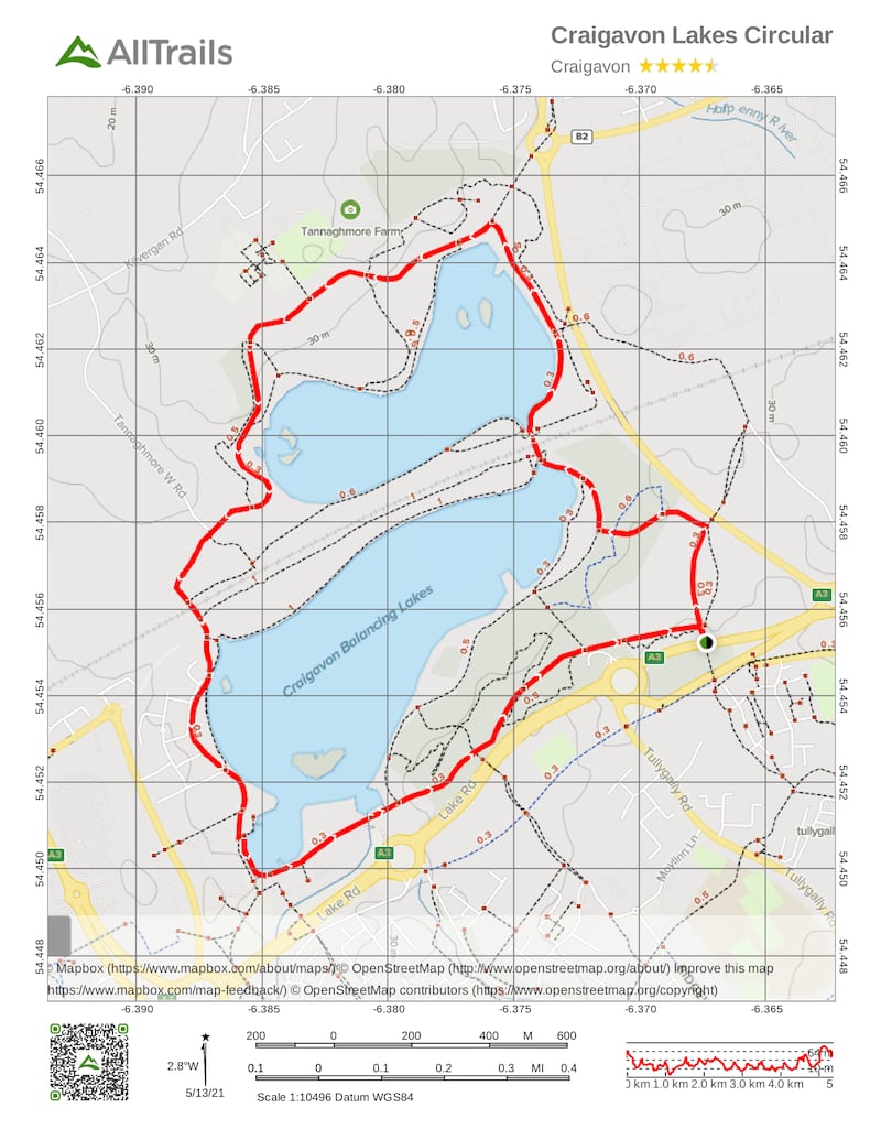
Name: Craigavon Lakes
Length: 5km
Route type: Loop
Footwear: Road or Trail Runners
Terrain: Varied
Amenities: Toilets and refreshments are available from the Craigavon Watersports Centre and Tannaghmore Animal Farm.
The following facilities are available for users with limited mobility:
- Disabled toilets
- Disabled parking
Route Information: From the Craigavon Watersports Centre car park, start walking on the wide tarmac path beside the lake and walk in either a clockwise or anti-clockwise direction, keeping the lake to one side. For the first half of the walk, follow the signs for Tannaghmore Gardens. Once you have reached the gardens, follow the signs for Craigavon Water Sports Centre to return to the car park. During the walk, you will come to two bridges. You must pass under these in order to complete the circuit of both lakes. It will take approximately 45 mins to 1 hour to complete the walk and at one point you may be up to 100 metres from the water's edge. When you approach the railway line, you may want to take a short detour into the Local Nature Reserve on either side of the railway line, to view the wildflowers, butterflies and orchids, however it should be noted that the path for this walk has yet to be laid and is therefore currently unsuitable for disabled users and pushchairs. (Aided by: Trek NI)
Hike name Slieve Gullion summit
Distance 13.9km
Elevation gain 610m
Approximate duration 3 hours
Difficulty Advanced
Route type Loop
Starting point See AllTrails Slieve Gullion
Amenities Toilets, cafe, parking
Dog-friendly? Yes
Tips The path on route down can disappear at times so keep alert
Name: Cam Lough
Location: Google Map: 83 Newtown Road, Camlough
Brief description: Large disused reservoir and lake in a steep valley between Camlough Mountain and Slieve Gullion. Also called "crooked lake" for its ribbon shape which acts as a wind funnel, giving it more predictable and calm conditions than Lough Neagh
Amenities: Toilets, car park
Lifeguard: No
Water quality: Good. Its aquatic flora and fauna depend on unpolluted water, according to the Department of Agriculture, Environment and Rural Affairs
Tips: Well-organised swim zones with orange and white buoys range from a 75m course up to 750m. There's also a 25m laned pool handy for lengths
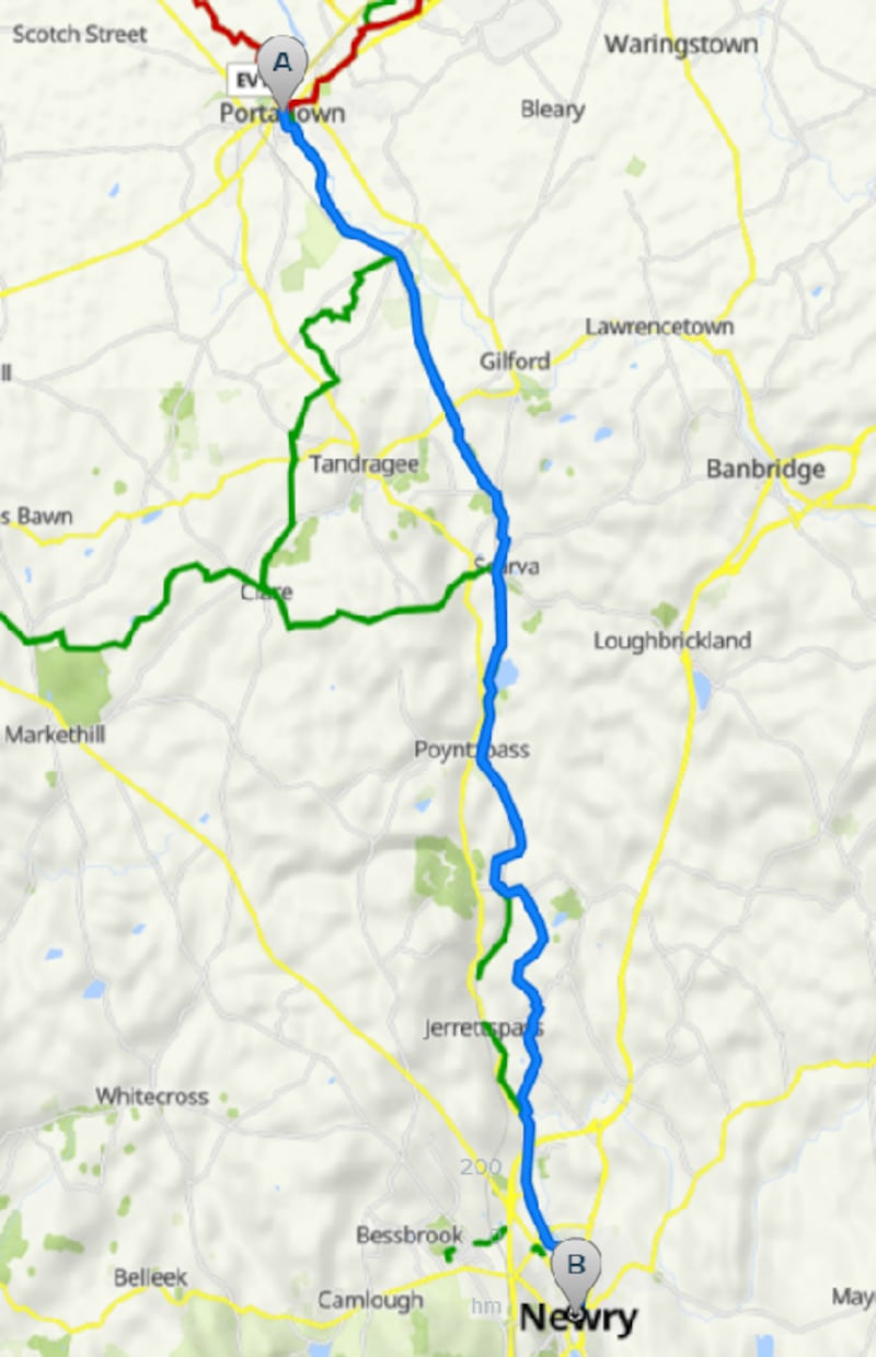
Name: Newry Canal Way
Start location: Portadown
Route: Starting in Portadown, this route heads more or less straight for the county border passing the villages of Scarva and Jerrettspass to finish at the Town Hall in Newry.
Distance: 32km
Time: 2-3 hours
Highlights: Plenty of flora and fauna to help bring the canal and towpath to life.
Look out for: Moneypenny's Lock, the last lock on the canal before the River
Bann and the location of a small museum.
Tips: Though flat there are some gravel paths and boggy areas along the way so no racing.
Park name: Gosford Forest Park, Markethill
Amenities: Beautifully crafted wooden playground among the trees, walking, mountain bike and horse riding trails.
Special features: There's a special "pump track" where beginner or experienced cyclists can improve their riding skills. Game of Thrones fans will recognise Gosford Castle used as a location for the hit TV series
Access: On-site car parking. Google Map "Gosford Forest Park".
Dogs: Yes on leads and the Green Dog Walkers Pledge encourages all dog walkers to always clean up after their dog and encourage others to do so.
Tip: Bring a picnic and use barbecue facilities and picnic tables next to playground.

Name: Palace Demesne, Armagh
Equipment: Dips, leg raise, pull-up, assisted pull-up, obliques, leg press, shoulder press, lateral pull-down, cross trainer, fitness bike.
Location: Google Maps
Information: Play area for kids and plenty of walking and running trails. Hosts a park run on Saturday, and the park has two car parks.
Get Active Series
- 32 great walking routes in Ireland - one in each county
- 32 great hikes in Ireland
- 32 great running routes
- 32 great outdoor swim locations
- 32 great cycling routes
- 32 great parks
- 32 great outdoor gyms


