When mulling over the job description of ordnance survey mapper, the thought of being dramatically winched onto rugged, windswept and dangerously inaccessible rocks in the Atlantic Ocean is probably the last thing that comes to mind.
No, it’s not the plot of an ill-conceived action movie. The above process forms an essential part of attempts to modernise maps for Ireland’s territorial seas, which cover an estimated 220 million marine acres (over 11 times the land mass of the island of Ireland).
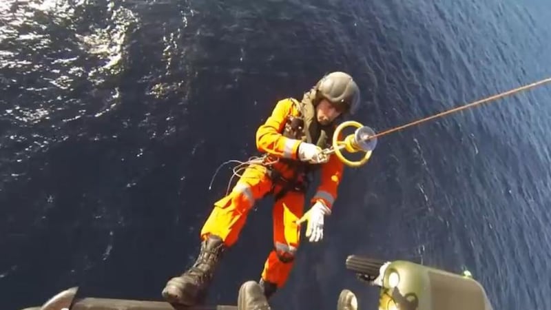
Codenamed Operation Baseline, the project is being carried out on a collaborative basis between the Air Corps, Navy, Ordnance Survey Ireland (OSi) and the Department of Foreign Affairs.
Exhilarating outings
Not content to take a back seat, the men and women of the OSi are keen to grasp the opportunity of such exhilarating outings with both hands. They’re the ones who are responsible for making daunting sea and air excursions in order to retrieve vital data, according to Operation Baseline co-ordinator Andy McGill.
“Because some of these rocks are out in the Atlantic Ocean, we would not be able to access them,” says McGill, who works for the OSi.
“For some of them we’d go out on a Navy ship and use a Rib to access rocks. Depending on the height of the rock above the water that may not be possible, so you’d have to be winched on from a helicopter.
“We’ve been advised and trained by the Air Corps and Navy, and we’ve also done training ourselves such as rock climbing and ropework before we engage in any of this. It’s quite hazardous in comparison to what we normally do,” adds McGill, who is happy to leave the lives of his employees in such capable hands.
“These guys lift people off moving boats, so a stationary rock is probably easy enough for them,” he says.
Exciting spectacle
As evidenced by the videos, it’s a pretty exciting event for those involved. Indeed, imaginations can tend to run wild at the mention of remapping territorial waters and the perceived effect this may have on claims to resources.
However, the main function of their endeavours isn’t to lay claim to undersea oil deposits, lucrative gas fields or even long-lost gold doubloons from pirate shipwrecks.
The ultimate aim is altogether more mundane, but necessary nonetheless.
Baselines are effectively waypoints used for nautical navigation in the seas around Ireland.
First measured in 1959, Operation Baseline seeks to remeasure the State’s maritime territory, which stretches out as far as 12 nautical miles, as stipulated by international conventions.
When complete, the project will create a minutely detailed outline of the State’s territorial limits and will enable the Air Corps and Navy to pinpoint the exact locations of operational units on the grid at all times.


