

When the weather is good, there is so much to do outdoors in Ireland – solo, or with family or friends. Here are seven activities - with locations, descriptions, tips and some maps for a general guide.
Below you can read John O'Dwyer's pick for a great walking path, Conor O'Keeffe on a running route, Rozanna Purcell recommends a hiking trail, Mary McCarthy on an outdoor swimming location, Ian O'Riordan picks a cycle trip, Sylvia Thompson on a family-friendly park and Fiona Alston selects a popular outdoor gym.
And remember, whatever you do and wherever you go, please be safe. And enjoy.
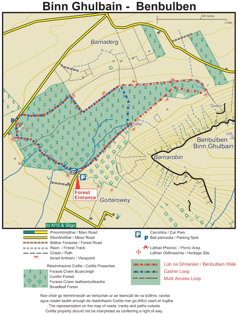
Name Ben Bulben Loop
Distance 5.5km
Approximate duration 1.5 hours
Difficulty Easy
Starting point Google Maps Trailhead carpark (grid reference G 674 460); you can follow this sligowalks.ie guide
Amenities Small car park
Attractive woodland walk offering stunning scenery and the awe-inspiring prospect of Benbulbin towering just above the trail.

Name: Benbulben Forest Loop
Difficulty level: As this Benbulben run doesn't actually involve climbing the mountain, the trail is quite flat which makes it a great place for faster training runs.
Parking: The car park for the Benbulben loop is located just off the N15, 8km north of Sligo. Throw "Gortarowey Forest Recreation Area" into Google Maps and it'll take you to the car park. The turnoff is signposted and it's a simple walk from there once you're parked up.
What to bring with you: While not the most the challenging walk, it's still important to be comfortable on the Benbulben forest loop. Take some sturdy walking boots and weather appropriate coats or jackets depending on what the weather is set to be like. Check your weather app in the morning and pack appropriately. A bottle of water and a few snacks never go amiss either.
Route information: The Benbulben forest loop is a great run for anyone looking to get out of the city and into the trails under the watchful eye of the Benbulben mountainside. Also known as the Gortarowey loop, this Benbulben loop is a looped route that starts in a sheltered forest before emerging alongside the grandeur of Benbulben, the most unique of the many mountains in Sligo. After a jaunt in the shadow of the ancient mountain, you'll then loop back to encounter some stunning panoramic bay views before then turning for home. The Benbulben loop is perfect for those looking to change scenery for their 5km run or if you desire a peaceful place to run multiple loops for your weekly 10km run.
The trail is quite flat and will give you an opportunity to take in the natural surroundings should you wish to. Or feel free to let loose and gun it around the loop for your new 5 or 10km personal best. You’ll start this run off from the car park at Gortarowey Forest Recreation Area. From the car park, the initial stretch is a short run through pretty shaded woodland that conceals the natural splendour of what lies ahead. Once you’re through the preliminary section of forest, you’ll emerge into an opening where the vast form of Benbulben head rises up on your right-hand side. Follow this gravel path and appreciate the striking close-up views of Benbulben mountain that this path affords you. If you’re here on a sunny day when the light glints off the side of the mountain, even better! Once you’re parallel with the mountain summit, thick forest on the left-hand side starts to form and will stay alongside the path for the majority of the trail.
On this Benbulben Loop, you'll come across an array of colourful flora, as well as foxes and wild hares. The Sligo countryside also contains many varieties of tree to look out for on the way. The path then turns right, providing the best chance of getting up close and personal with the mountain. Once you've got your close-up photo of Benbulben for Strava, the path then loops left and the landscape totally changes, presenting gorgeous sloping views beyond fields, forest and roads towards Donegal Bay. On a clear day, the jagged peaks of Slieve League should be visible across Donegal Bay, as should the stately spires of Classiebawn Castle and the rest of Mullaghmore head. Speaking of stunning views, if you take on a Benbulben hike and the weather is playing ball (never a guarantee), you should even be able to get a glimpse of Croagh Patrick from the summit.
Continuing the path along the forest and with Benbulben to your left, you’ll eventually be treated some more spectacular vistas, except this time it’ll be Sligo Bay that you’re looking towards. Beyond the slanting countryside, farmland and shimmering water, the grand outlines of the Ox Mountains will be visible in the distance. The unusual but no less magnificent outline of the 1000ft-high Knocknarea should also be clear.
Making your way back to the car park: The path will eventually turn left, and you'll head back through a forest trail and towards the car park where the loop comes to an end. Timing is never easy but for the most epic experience of the Benbulben run, try to head out on a clear day at late afternoon or early evening (depending on the time of year) so you can catch the golden light of the low sun on the steepest sides of the mountain. You'll also be able to catch a gorgeous orange sunset as it goes down beneath Sligo Bay. Other great spots to visit in the area, if you have the time, include Strandhill, Mullaghmore and Glencar Waterfall. (Aided by: activeme.ie and Sligo Walks)
Hike name Benbulbin
Distance 13.5km
Elevation gain 544m
Approximate duration 3.5-4 hours
Difficulty Advanced
Route type Out and back mostly, small loop.
Starting point See AllTrails Benbulben Loop Trail
Amenities Parking (limited)
Dog friendly? No
Tips Aside from getting there early for parking, I would just say wear hiking boots. It's very boggy.
Name: Mullaghmore
Location: Google Map: Mullaghmore beach
Brief description: Sheltered sandy beach. The bathing area is about 300m long though the beach is 2km in length
Amenities: Parking, toilets
Lifeguard: Summer
Water quality: Sufficient – Sligo County Council (Sampled on 07/09/2020
Tips: Really nice for a swim before dinner.

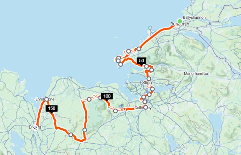
Name: Atlantic coast route
Start location: Sligo and/or Bundoran/Ballina
Route: Three stages of the EuroVelo Atlantic Coast Route, first from Bundoran to Sligo (71km), Sligo to Coolaney (27km), and Coolaney to Ballina (73km), can be tackled in any order or direction.
Distance: 171km
Time: Dependent on stage
Highlights: A sort of mini Tour de Sligo taking in the best of the northwest, including Ireland's only table top mountain, the mighty Benbulben.
Look out for: The steep climbs on Stage 3 around Easkey Bog
Tips: Also part of the trans-national EuroVelo 1, the Atlantic Coast Route running from the North Cape in Norway to Porto in Portugal. (For the full EuroVelo1 Route see www.eurovelo.com)
Park name: Doorly Park, Sligo town
Amenities: Part of the Cleveragh Demesne, this park has woodlands and wetlands for walks and boating.
Special features: The playground has a good range of play equipment.
Access: Free car parking. Google Map "Doorly Park".
Dogs: Yes
Tip: Consider walking to the park from Sligo town along the Garavogue River.
Name: Mitchel Curley Park, Sligo Town
Equipment: Mix of cardio stations, including walker, cross trainer, pedal cycles and rower.
Location: Google Maps
Information: The views from this park are spectacular, including of Benbulbin.
Get Active Series
- 32 great walking routes in Ireland - one in each county
- 32 great hikes in Ireland
- 32 great running routes
- 32 great outdoor swim locations
- 32 great cycling routes
- 32 great parks
- 32 great outdoor gyms


