Main points
- “Extremely destructive gusts” of wind are forecast as the country is preparing itself for the onset of Storm Éowyn tonight.
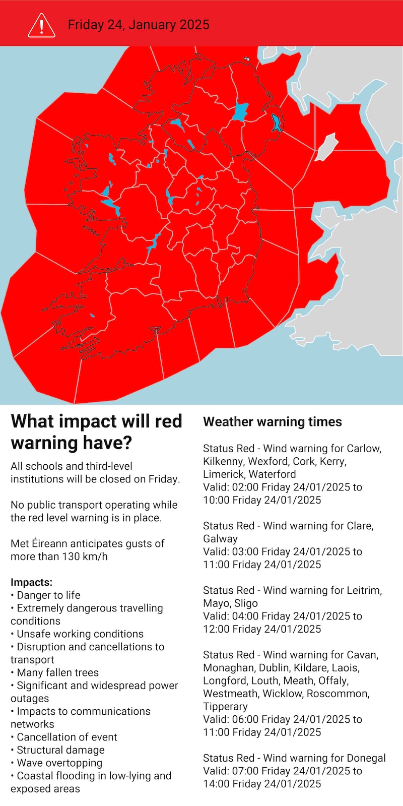
- All schools and third-level institutions will be closed and there will be no public transport operating while the red level warning is in place. Dozens of flights have also been cancelled
- Businesses are making last-minute preparations and asking employees to work from home tomorrow
- Retailers are preparing to close for the duration of the warnings
- All national parks and national parks and wildlife service sites will be closed
- Storm Éowyn: How serious is a red weather warning, and how should I prepare?
That’s all for our live coverage tonight, thanks for staying tuned. The Irish Times live coverage of Storm Éowyn continues early on Friday morning at irishtimes.com
The newly appointed Minister for Social Protection Dara Calleary has confirmed that the Humanitarian Assistance Scheme will be available to provide support to those living in properties directly affected Storm Éowyn.
The Humanitarian Assistance Scheme prevents hardship by providing income-tested financial support to people whose homes are damaged from flooding and severe weather events and who are unable to meet costs for essential needs, household items and structural repair.
The first of the weather warnings for tonight/Friday has just come into effect. A status yellow rain warning is currently in place for counties Cork, Kerry, Waterford and Wexford and will remain so until 5am on Friday.
Met Éireann has warned of localised flooding due to the rainfall.
Journalist Jen Hogan has written a survival guide for parents working from home during the bad weather on Friday.
It includes six top tips to help navigate children at home for the day while you’re working and can be found here.
IFA President Francie Gorman has advised farmers to take every precaution over the next 24 hours as Storm Éowyn arrives in the early hours of Friday morning.
Gorman has advised farmers to check their farmyards and put in place whatever safety procedures are needed to safeguard themselves and their livestock until the storm passes.
“Farmers should review whatever measures they normally take when Met Éireann issues a storm advisory. Check buildings, gates, doors, vehicles and equipment to ensure they are secure,” he said.
“Over the next 24 to 48 hours, farm families will face challenges in carrying out their work. It is absolutely essential that farmers think of their own safety, and the safety of their families and their neighbours.”
The Irish Coast Guard is appealing to the public to “stay back, stay high and stay dry” from all coastal regions during Storm Éowyn.
The public is being advised that conditions around coastal regions, including cliffs, piers and beaches will be extremely dangerous during the status red and status orange conditions and in the days after.
A high surge advisory has been issued for all coasts, with wave overtopping expected in exposed low-lying coastal areas, especially on Atlantic coasts.
The leap to remote teaching during the Covid-19 pandemic means many schools are much better equipped to shift to online learning or place assignments on shared digital platforms.
At Ardscoil Rís on Griffith Avenue in Dublin principal John McHugh said the school has opted to put homework and study assignments on its Google Classroom platform instead of live classes.
Read Education Editor Carl O’Brien’s full piece here.
Dublin Airport has said a number of airlines have already cancelled flights scheduled for Friday morning. As of 6pm on Thursday evening, 45 departures have been cancelled for Friday, as well as 44 arrivals.
Bon Secours Health System is implementing specific measures tailored to hospitals in each of its locations in Dublin, Cork, Tralee, Limerick, and Galway.
Patients impacted will be contacted directly to reschedule their appointments at the earliest convenience, minimising any disruption to their care, it has said.
Essential services will remain operational, with dedicated teams available to handle urgent medical needs. Contingency plans have been activated to address potential disruptions, ensuring continued support for critical cases.
Hospital-specific updates regarding Friday:
- Dublin (Glasnevin): Essential services, including in-patient care, urgent surgery, and oncology, will continue. Other services will be cancelled or rescheduled to Friday afternoon, weather permitting.
- Cork: Essential services will remain operational, while non-essential services will be cancelled or rescheduled on an ad hoc basis, depending on weather developments.
- Limerick: The hospital will close tomorrow for all scheduled elective outpatient and day-case activity, but inpatient care will continue. The hospital will reopen on Saturday as per weather conditions and Government guidance.
- Galway: The hospital will be closed on Friday. All elective procedures and admissions are cancelled, and departments will provide limited essential cover. Normal services resuming on Saturday as per weather conditions and Government guidance.
- Tralee: All elective procedures scheduled for Friday have been cancelled. Essential staff will remain on site up until 5pm and arrangements have been made to accommodate these staff in the hospital overnight.
Some operational changes and flight cancellations have been made across Aer Lingus’s network for Friday morning, with potential for further changes as the weather event unfolds.
The airline has issued a statement saying that “if your flight is disrupted, you will be notified directly”.
It has advised customers to:
- Please check your flight status for the latest updates.
- Check information on the operation of your departure airport – Airports by Region.
- Allow extra time to travel to your departure airport.
- If your booking was made through a third party (such as a travel agent, online agency or another airline), please be aware that they may receive flight status updates on your behalf.
There is no legal requirement for employees to be paid if they are unable to work during an extreme weather event unless the business closes or they are told to stay at home, according to a human resources (HR) professional.
However, Caroline Reidy of consultancy firm the HR Suite advises that owners and workers put safety first when considering how to deal with the impact of Storm Éowyn.
Work Correspondent Emmet Malone has the full report here.
Cork City Council is working with Cork Simon Outreach, Community Policing, Good Shepherd Services, De Paul Ireland and others to provide support to rough sleepers in the city, journalist Olivia Kelleher reports.
From early today outreach teams sought out and engaged with rough sleepers to make them aware of the warning and of the services available to them.
For the duration of the red alert, Cork City Council has access to additional beds in multiple locations so that all rough sleepers can be facilitated, should they accept an offer of a bed.
Cork City Council’s Severe Weather Assessment Team and Operations crews will continue to monitor the situation.
Work Correspondent Emmet Malone reports: The country’s creches and early education services are set to stay closed for the day on Friday.
Though there may be exceptions among individual operators, the Department of Children’s Early Years division said: “After the red warning expires, safety checks may be needed to assess whether any damage has occurred to ensure the safety of children, staff and parents.
“Providers may need time to prepare to reopen. Because of these factors, concerns about safe transport and the unpredictable nature of the red warnings, the department recognises that it is not possible or practical for ELCs and SACs to open on Friday.”
Dublin City Council has also said all of its services, including public offices, libraries, sports centres recycling centres and parks will remain closed for the day.
Northern Correspondent Seanín Graham reports: Police in Northern Ireland have declared Storm Éowyn a major incident.
Speaking at a press conference at Stormont on Thursday, Assistant Chief Constable Davy Beck warned that the North will experience its strongest winds since the “Boxing Day Storm” of 1998.
Winds of to 100 miles per hour are forecast for some coastal areas during the red alert between 7am and 2pm on Friday.
The senior PSNI officer is leading the emergency response and said they are anticipating “widespread disruption in terms of both infrastructure and the impact on public services and agencies”.
“But we are preparing for this, and we will do all we can in terms of those preparations to minimize the potential risks for the communities in Northern Ireland,” ACC Beck Beck said.
Translink has cancelled all public bus and train services during the peak of the storm while all schools have been advised to close.
An emergency alert will be sent to phones in Northern Ireland this afternoon.
The Met Office says there is a danger to life.
Stormont First Minister Michelle O’Neill was also present at the press conference and said there “is a danger in thinking that this is just like any other storm” but that is “not necessarily the case”.
ACC Beck confirmed the PSNI has been liaising with the health department and trusts.
“They will be advising people as to potential attendance,” he added.
“I expect that routine, planned elective surgery and outpatient appointments will be impacted, but people should be advised by the trusts in advance.
“It will have an impact on those services.”
Extensive damage to electricity infrastructure is anticipated and widespread power outages are expected, ESB Networks has said.
“ESB Networks crews and partner contractors around the country are in a full state of readiness and are making all necessary preparations in order to respond,” it said.
“ESB Networks crews will mobilise tomorrow, as soon as it is safe to do so, to assess the damage caused by Storm Éowyn, making the network safe, restoring electricity supply and switching customers back remotely where possible.”
Based on previous experience of similar windstorms, ESB Networks anticipates power restoration will take a significant number of days to complete.
Given the predicted extent of the damage nationwide, estimated restoration times (ERTs) will only be provided once our teams have assessed network faults and these will then be available to view throughout Saturday on www.PowerCheck.ie.
ESB Networks is asking customers to consider preparations in the event of losing their electricity supply if their area is affected by Storm Éowyn. This includes having torches, spare batteries, fully charged phones and having their MPRN number (found on the top right corner of each electricity bill) to hand.
Ahead of the arrival of Storm Éowyn, the charity DePaul is encouraging all rough sleepers and vulnerable individuals to stay indoors.
“We are calling on any individuals who may have influence over those who are rough sleeping to encourage them to obtain shelter for tonight as conditions are expected to be potentially life threatening,” said DePaul’s chief executive David Carroll.
“We would urge all people who are sleeping rough to make contact with their local authority homelessness or street outreach services or the Gardai. The main contacts for support are the Dublin Region Homeless Executive (DHRE) and outside of Dublin, the city and local councils.
The DSPCA is urging pet and animal owners to take extra precautions in ensuring their animals stay safe during this time. Do not, under any circumstance leave pets outside, it said.
Tips include:
- Make sure all pets are kept safe indoors.
- Ensure that all equine and farm animals are stabled, have access to shelter and that all fencing is secure.
- Remove any loose objects such as ornaments etc in gardens, as these may be lifted by wind and harm pets/animals nearby.
- Check that garden gates and fences are secure when letting pets out for toilet duties. Consider keeping them on the lead, walking them before and after the storm, or going into the garden with them with a torch.
- Ensure your pets are wearing collars with up-to-date identification tags, or are microchipped. This helps reunite lost pets with their owners more quickly if they run away during stormy conditions.
- Have extra blankets ready for warmth, should power or heating be affected.
- Be cautious of standing water after storms. It may contain harmful bacteria or chemicals that pets can ingest.
Suzanne McGovern, Director of Operations at the DSPCA said: “Storms and heavy winds are unpredictable and can be very frightening for animals. It’s important that all pet and animal owners put the necessary measures in place to take care of them, and to ensure utmost safety.”
Businesses across the State are making last-minute preparations and asking employees to work from home in advance of the arrival of Storm Éowyn in the early hours of Friday morning.
Retailers are preparing to close for the duration of the status red weather warnings, which Met Éireann has extended to all counties at various intervals from 2am on Friday, with the storm expected to bring widespread destructive winds.
Read the full story here.
Dublin Bus services will not operate from 4am to 11am on Friday. Services will be severely impacted in the hours before and after the status red warning is in effect, the company said this afternoon.
Although the status red warning ends at 11am for Dublin, services will be reintroduced on a gradual basis as employees return to work safely.
“The safety of our customers and employees is of the highest importance,” it said. “Dublin Bus is working with the NTA and other public transport operators in preparation for Storm Éowyn. We are taking advice from Met Eireann and the National Department of Fire and Emergency (NDFEM), and will continue to monitor the situation as the storm evolves. Our Severe Weather Team is meeting regularly to assess the situation and prepare for all eventualities.”
Customers are advised to plan their journeys and check its website and X account. Customers can also call the Consolidated Contact Centre on 0818 294015.
Dublin Express has cancelled some services that were planned to run on Friday due to the red weather warning.
Subject to changing weather conditions, services are currently planned to restart as follows, on Friday afternoon:
Dublin Airport to Dublin City Centre from 13.00
Dublin City Centre to Dublin Airport from 13.00
Belfast to Dublin City Centre from 15.20
Dublin City Centre to Belfast from 18.10
Customers are advised to check www.dublinexpress.com for the latest updates before they travel.
A spokesperson for Dublin Express said: “Safety is our number one priority. As a result we’ve cancelled some services that were planned to run during the red weather warning on Friday 24 January. We’re asking customers to check our website before travelling. We are closely monitoring the weather conditions and will update our website when there is new information to share.”
Dublin Express is seeking to proactively contact customers who have already booked to travel in the red weather warning time period. It is offering free ticket refunds for customers who are affected. More information is provided on www.dublinexpress.com.
All national parks and national parks and wildlife service (NPWS) sites will be closed on Friday, the Department of Housing has said. Facilities and amenities on all sites will be closed and will be opened only following review of all conditions.
“We are asking the Public not to visit National Parks and NPWS sites tomorrow, Friday, January 24th, and until further notice due to Storm Éowyn,” it said.
“Please follow the weather warnings from Met Éireann and advice from the National Emergency Co-ordination Group and the National Directorate for Fire and Emergency Management.”
The opening hours of Sport Ireland’s campus in west Dublin will be affected by Storm Éowyn and the status red warning.
The campus will close at 10pm on Thursday and reopen at 12 noon on Friday, with facilities reopening at 1pm. “The reopening is subject to weather conditions and inspection of facilities,” it said in a statement.
The Leinster Swimming Open Gala due to take place in the Sport Ireland National Aquatic Centre on Friday, January 24th will instead take place on Saturday 25th and Sunday 26th.
The most dangerous recorded storm in Irish history was Storm Debbie in September 1961.
This was not an Atlantic storm but a rare tropical cyclone which slammed into Ireland on September 16th, 1961.
It caused 18 deaths in the Republic and six in Northern Ireland.
Four members of he same family were killed when a tree fell on their care near Ballinagh, Co Cavan.
There was no prior warning of the storm in Ireland and the aftermath did not dominate the news as all the Irish newspapers were preoccupied with the Siege of Jadotville in the Congo where Irish peacekeeping soldiers were besieged in the breakaway province of Katanga. There were fears, unconfirmed, that dozens of Irish soldiers had been killed. The rumours proved to be unfounded.
The most famous storm in Irish history was the Night of the Big Wind on January 6th, 1839.
This storm killed at least 200 people and destroyed thousands of cottages across Ireland.
The event was so memorable that older people could qualify for the first Old Age Pension which came into being in 1909 if they could remember the Night of the Big Wind.

The DSPCA is urging pet and animal owners to ensure that their animals are not left outside during the storm.
It has also advised that all animals be stabled, have access to shelter and that all fencing is secure.
They should ensure that all pets are wearing collars with up-to-date identification tags, or are microchipped. This helps reunite lost pets with their owners more quickly if they run away during stormy conditions.
Gas Networks Ireland will temporarily suspend planned works on Friday 24 January, in all counties where status red weather warnings are in place as a result of Storm Éowyn. Emergency repairs will however continue in all counties.
GNI has said it can assure its 725,000 customers that it does not anticipate any disruption to gas supplies during Storm Éowyn. Ireland’s gas network is one of the safest and most modern gas networks in Europe and with the added security of its 14,725km of pipeline being underground it is unlikely to be impacted by adverse weather conditions.
Northern Ireland First Minister Michelle O’Neill has issued a statement calling on people to avoid all unnecessary travel where possible. Schools will be closed and workers are being asked to work from home.
She added: “The Executive is working closely with emergency services and agencies to ensure a coordinated response to protect people and communities, but we all have a part to play.
“I urge you to take a moment to check in on family, friends and neighbours - especially those who may need extra support.”

Insurance Ireland is advising policyholders on steps to take to minimise the risk of damage from this storm, as well as advice for motorists to heed the warnings during severe weather events and avoid any unnecessary journeys. In the event of storm damage to your home or car, insurers will be on standby to assist customers to recover as quickly as possible.
Motor:
- Insurance Ireland advises motorists to heed the warnings in place from the authorities and avoid all non-essential travel.
- Motor insurance cover operates as normal, as your legal liability to others is covered by all policies. Damage to cars caused by the storm is covered by comprehensive motor insurance policies. Third party fire and theft policies do not provide cover for storm damage to your car.
Home:
- In advance of the forecasted high winds, tidy away or tie down any loose items in the garden which could be blown around by gusts, check for loose roof tiles.
- In advance of the storm, it’s helpful to clear gutters and check that any drainage systems aren’t blocked with leaves.
In the event of storm damage to your home or car, Insurance Ireland has the following advice:
- Household buildings and contents insurance policies cover damage caused by storms.
- Damage to cars is covered by comprehensive motor insurance policies.
- Insurers will usually pay for the cost of temporary repairs, so please keep receipts.
- Insurers will also usually pay for the cost of alternative accommodation, if the home becomes uninhabitable.
- Householders should check the full extent of their policies and contact their insurer or broker as quickly as possible after the event.
Met Éireann chief forecaster Eoin Sherlock has warned the public against any sense of weather warning fatigue.
Mr Sherlock said there have been a lot of weather warnings since the coded weather warnings were introduced, but this one for Storm Éowyn is different.
“There are a lot of storms, but you will know from the last few responses that we do most of this in the virtual world. The fact that we are in the National Emergency Co-ordination Group today signifies that this is amongst the most dangerous storms that Ireland will have faced. This at the extreme end of the Atlantic storms.”
The atmosphere at the NECG group media briefing was particularly grim. Mr Sherlock said there has not been a nationwide red weather alert since Storm Ophelia in 2017.
The energy in the storm is as a result of freezing weather in the US north-east which forced President Donald Trump’s inauguration indoors meeting warm air from the Gulf of Mexico which created an air current that was picked up by the jet steam. As it crosses the Atlantic it will exit the jet stream like a “spinning top and with incredible intensity. Unfortunately, we are in the firing line with this storm,” he explained.
It will pass over the country “relatively quickly” but will leave considerable damage behind.
Atlantic facing coasts in the south-west will experience the highest wind speeds, but inland areas may experience wind that they never experienced before. “There are going to be impacts everywhere. Everywhere is at risk,” he said.
The winds out to sea off the coast of Ireland will be Storm Force 12, these are the equivalent of Hurricane-force winds. Climate change is causing increased wind speed and rain.
National Emergency Co-ordination Group director Keith Leonard urged the public to tie down any furniture. He said people should not go outside even if the red wind warning passes as an orange wind warning will follow immediately afterwards nationwide until 4pm.
He said employers need to be as “flexible as possible with employees and they have a duty of care with employees which trumps other avenues” and he added: “We are going to see a huge number of trees down tomorrow. We are going to be without electricity, broadband and water. There is going to significant disruption.”
Ryanair cancellations ‘inevitable’
Airline Ryanair cautioned that Storm Éowyn would “inevitably” cancel some flights but said conditions would determine which services, writes Barry O’Halloran.
Eddie Wilson, chief executive of Ryanair DAC, noted that the carrier got 95 per cent of scheduled flights away during Storm Daragh last month.
He advised anyone with bookings to check their emails and keep an eye on the airline’s website for updates.
“Our people decide what to cancel based on conditions,” he explained. “It’s inevitable there will be some cancellations.”
He added that the airline planned to operate its schedule as normal, but would axe flights as necessary, rather than cancelling all services in advance.
Schools to close in Northern Ireland on Friday due to storm warnings
All schools in Northern Ireland have been advised to close on Friday amid a top-level red warning for wind issued for Storm Éowyn.
The Met Office has issued a red alert, which covers all of Northern Ireland from 7am on Friday until 2pm and is warning of “very dangerous conditions” and “widespread disruption”.
“A red weather warning has been issued for Storm Eowyn and the Education Authority has advised that all schools should close tomorrow,” Stormont’s Education Minister Paul Givan said.
“I understand this will impact on the work of schools and indeed on other businesses and services, but the decision has been taken to avoid any potential risk to life for children and young people as well as staff. “Schools should put plans in place today for remote learning so that pupils can study at home.”
The last time all schools in Northern Ireland were advised to close due to weather was due to Hurricane Ophelia in 2017. Forecasters are warning of flying debris resulting in danger to life, as well as “very dangerous” driving conditions because of fallen trees. There may also be power cuts, damage to buildings and homes, and delays and cancellations to bus, train, ferry services and flights.
A Met Office spokesman said peak rush hour wind speeds of 80-90 miles per hour are expected across Northern Ireland, with up to 100mph in some exposed locations.
“An extremely windy spell with disruption and potentially damaging winds tomorrow morning,” he told the news wire PA.
“It’s a big deep area of low pressure covering Northern Ireland hence the warning that covers Northern Ireland.
“Top wind speeds are expected on higher ground or exposed locations, potentially around coasts.” The record for a gust in Northern Ireland is 124mph in Kilkeel in Co Down in January 1974.
Ireland’s independent radio stations are ramping up preparations to ensure they are ready to quickly provide updated information to householders and businesses over the airwaves during the coming days, as the country braces itself for Storm Eowyn.
Storm Eowyn is expected to be extremely severe in terms of damage and danger, and therefore information provided through our radio stations will be needed by householders or businesses if electricity, water, or telecoms are affected, or if public safety information needs to be rapidly communicated by organisations like the local authorities, the Gardai or other emergency services.
Michael Kelly, Chief Executive of the Independent Broadcasters of Ireland commented today: “Our stations have ensured they are ready. At times of severe weather like this, radio is a vital source of information and householders or businesses are always advised to keep their FM radio nearby with spare batteries so they can hear news updates over the airwaves from our stations in relation to damage assessments, repair outlooks and other essential local and national information.”
Mr Kelly added: “Our 34 local, regional, and national stations are prepared. We know from past experience that mobile phone network sites, or indeed mobile phone handsets themselves, can be affected by power cuts, but the FM system is resilient and can communicate directly without need for broadband or internet access. FM provides local and national news and information directly to your radio. The independent radio sector has a total of more than 160 journalists across our stations as well as other essential staff dedicated to providing news updates and bulletins to listeners. Our people will be ensuring vital information is provided quickly to listeners, while keeping safe themselves.”
“We have diesel generators at our stations and at our transmitter locations around the country and, as our radio stations are critical infrastructure, we work closely with ESB Networks. We assure our listeners we will be doing everything we can to provide uninterrupted provision of news and information.”
The UK Met Office is forecasting wind speeds on the west coast of Ireland tomorrow morning gusting at between 161 and 191km/h potentially the strongest since Storm Debbie on September 16th 1961 which hit 182km/h at Malin Head.
That storm killed 18 people in Ireland, 12 people in the Republic and six in Northern Ireland. Hopefully, with a better warning systems this time, there will be no repeat of that death toll.
The chief executive of Retail Excellence Ireland, Jean McCabe is urging the public not to “panic buy” in advance of Storm Éowyn tomorrow.
Speaking on RTÉ radio’s Today with Claire Byrne show, she said that most shops would reopen after the Red warning was lifted, so there was no need to stock up on items as had happened prior to previous storms.
BBC Northern Ireland weatherman Barra Best has just stated that Storm Éoywn will be the first time that the whole of Ireland has been in a red weather warning since the warning system was introduced in 2011.
The commentator’s curse - just as I was about to highlight why Northern Ireland has is not in the red zone, the UK Met Office has just upgraded the warning there to red.
The red warning will come into force at 7am and end at 2pm. It has warned of flying debris everywhere, large waves and very dangerous driving conditions.
Looks like the whole of the island of Ireland will be closed for business on Friday.
Met Éireann has updated its status red warnings and added a status orange wind warning for the whole country on Friday afternoon.
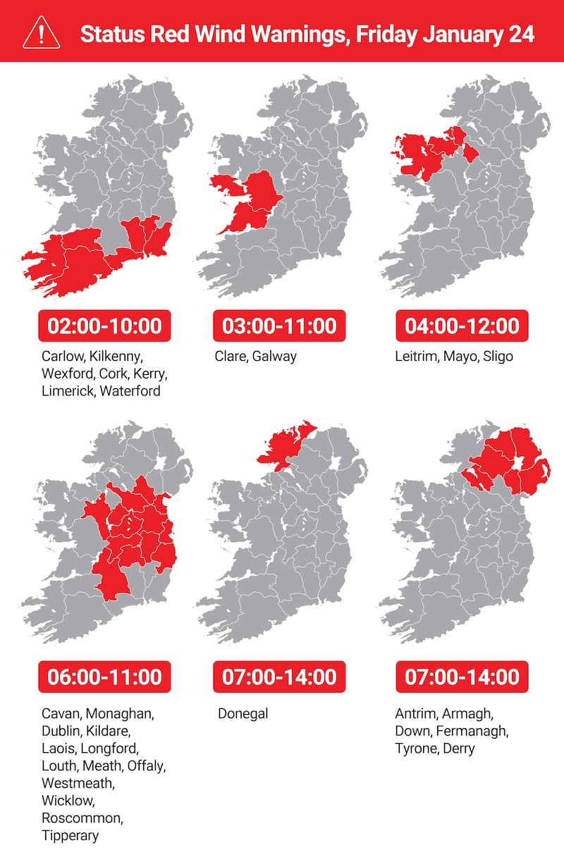
The status red wind warning for Carlow, Kilkenny, Wexford, Cork, Kerry, Limerick, Waterford is valid from 2am to 10am on Friday.
The status red wind warning for Clare and Galway is valid from 3am to 10am on Friday.
The status red wind warning for Leitrim, Mayo and Sligo is valid from 4am to 10am on Friday morning.
The status red wind warning for Cavan, Monaghan, Dublin, Kildare, Laois, Longford, Louth, Meath, Offaly, Westmeath, Wicklow, Roscommon, Tipperary is valid from 6am to 11am on Friday morning.
The status red wind warning for Donegal is valid from 7am on Friday morning to 2pm on Friday afternoon.
The status orange wind warning for the State will be in operation in all 26 counties until 4pm on Friday.
Why is the whole of the Republic of Ireland in the red weather zone and Northern Ireland only in the orange zone?
It’s not due to the fondness for the colour orange north of the Border.
Who better to explain it than BBC Northern Ireland weatherman Barra Best. He is one of the few living people to have a storm named after him - Storm Barra in December 2021.
So far the main takeaways from RTÉ's Morning Ireland coverage of the coming storm are the following:
• Storm surges and dangerous conditions pose significant risks, especially for swimmers and coastal areas.
• The RNLI (Royal National Lifeboat Institution) is prepared to respond, but advises people to avoid unnecessary risks and stay away from the water.
• Local authorities are preparing for extensive power outages and disruptions, and urge people to take precautions and stay indoors during the storm.
• Experts warn the storm could be as severe as Storm Ophelia in 2017, which left many without power for up to a week, and say people need to take preparations
Met Éireann forecaster Aoife Kealy has said many places are likely to experience wind speeds they have not experienced in decades.
She anticipates that the west coast will violent storm force 11 winds of 103km/h gusting to more than 130 km/h along western coasts.
Coastal parts of Kerry, Clare and Galway are most vulnerable.
She told The Irish Times: “This could be one of the more severe storms. There will be dangerous conditions nationwide with extremely damaging wind. Gusts above 130km/h are very possible. Our models are showing wind speeds easily in excess of that figure.
“Mean speeds as well will be easily above 80km/h and possibly even higher. People need to stay indoors at least through the red warning.
“There will be further impacts even after the red warning passes because the winds still will be strong so it may bring down fallen trees weakened during the red warning period. This will be a significant and very dangerous event.
“The winds may not exceed red levels, but it will still be quite dangerous.”
Met Éireann’s forecasted wind speeds for parts of the south-west and west coasts are among the highest ever predicted in Ireland.
Gusts of 162 km/h are predicted for Valentia Island in Co Kerry at 4am and at 6am at Mace Head in Co Galway.
A 154 km/h gust is expected to hit Bellmullet, Co Mayo at 9am and 149 km/h at Malin Head, Co Donegal by 1pm.
To compound matters Met Éireann has issued a new weather warning, this one a status yellow rain warning for Cork, Kerry, Waterford and Wexford from 9pm on Thursday night to 5am on Friday morning. This increases the risk of flooding.
National Emergency Co-ordination Group director Keith Leonard has warned that Storm Éowyn will be at the “very upper end of the Atlantic storms we have seen”.
He anticipates large-scale power and water outages, with restoration work being hampered by further bad weather on Saturday into Sunday. “People are going to have to bear with us as we try to restore them.”
All schools and third-level institutions will be closed on Friday and there will be no public transport operating while the Red level warning is in place.
He suggested that “under no circumstances” should people attempt to travel during the storm, and he urged employers to show flexibility towards their workers.
He advised the public to ensure that their mobile phones are charged overnight in case of emergencies.
All State services are now operating in “emergency mode”.
“We met yesterday and we heard about the plans with local authorities standing up all their local coordination groups,” he told RTÉ radio’s Morning Ireland.
“ESB and Irish Water have their crisis management teams and plans activated. So all critical infrastructure and essential services are operating now in emergency mode for the next 24 to 48 hours and we’ll have a meeting again at 10am.
“The key advice for this storm, it is an extreme storm at the very upper end of the Atlantic storms we experience, for those times that red-level warnings are in place - shelter at home, shelter in place, do not move out and particularly, do not travel on the roads during that period.
“The other key piece of advice - make sure your mobile phone is charged and if you find yourself in a really difficult situation, dial 999. Even if your phone is not showing a service, it may pick up a service from another operator, so that’s very important for the next 24 hours.”
Mr Leonard said the clean-up operation once Storm Éowyn passes will be “major”. “It’s really important to emphasise that when the warnings expire, the conditions that people are going to face, likely when they leave their homes and go out, are going to be quite extreme, particularly with the number of trees on the road.
“There’ll be very significant disruption to road networks and to public transport. Local authorities and key infrastructure operators will be out quickly to try and deal with that, but it’s going to be a major clean-up operation well into the weekend.”
Forecaster Joanna Donnelly on RTÉ Radio 1 said the impact of the storm is certain – it will cause widespread damage – but the timings may be updated during the day.
Met Éireann meteorologist Gerry Murphy has raised the possibility that Storm Éowyn could be the most violent storm to hit Irish shores in recorded history.
Some weather models are suggesting winds gusting at more than 160 km/h in Co Kerry and Co Galway.
He told RTÉ's Morning Ireland: “It’s a very significant storm, severe winds, destructive winds.
“A red warning is a threat to life and property, the winds, the wind speeds on red warning, are gusting above 130 km/h.”
He said Éowyn will bring severe and destructive winds, but we won’t know if it’s the worst to ever hit Ireland until after the event.
Met Éireann is urging the people to secure anything that needs securing. Though the wind will pass through by Friday afternoon, more stormy weather is expected on Sunday.
A 5am forecast for Ireland on Friday morning, by Meteologix.com, shows onshore winds in Co Kerry of 190 km/h in the Dingle peninsula and 180 km/h in the Comeragh peninsula. To put that in perspective, the highest wind speed during Storm Ophelia in 2017 was 156 km/h. The highest-ever recorded wind speed in Ireland was at Foynes, Co Limerick, on January 18th, 1945 with a gust measured at 182 km/h.
Meteorologist Gerry Murphy is urging the public to check the website met.ie for specific times for their local region for Storm Éowyn. Mr Murphy told RTÉ radio’s Morning Ireland that the level Red warning meant that all areas needed to take great care.
Storm Éowyn would be “primarily a wind event”, with winds of up to 130 km/h predicted, with heavy rain in some areas, particularly in the south of the country, which could lead to localised flooding. There was also the possibility of sleet and snow on high ground, he added.
The terminal aerodrome forecast (TAF) for Shannon Airport shows winds gust at 148 km/h at 3am on Friday morning.
By contrast, the highest wind speed recorded during Storm Darragh was 141 km/h, recorded at Mace Head, Co Galway, on Friday, December 6th, last year.
Schools, early learning and childcare facilities and third-level education institutions are set to close across the country on Friday, while the Road Safety Authority urged people to “avoid any travel” during the “unprecedented and life-threatening Storm Éowyn”. ESB Networks has also advised customers to make provisions for the possible loss of power as a result of the storm.


