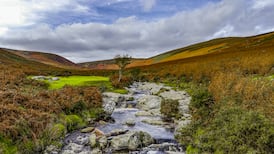
There are days at the end of winter when some match of light and atmosphere works to insist on the scale of the Mayo landscape at our rear – the great reach of mountain and moorland rolling far into the interior. How remarkable that anyone should have made this wild terrain the largest farm in Ireland.
Captain William Houstoun, of the 10th Hussars, was the son of a Scottish general and one-time governor of Gibraltar: a clannish family, then, of considerable means. In 1850, with the west of Ireland stricken by the Famine, young Houstoun asked Lord Sligo of Westport if he knew of any tract of land that could carry 10,000 sheep.
This was at the end of the infamous Highland Clearances, the forced evictions in the west of Scotland and its islands, to make way for sheep. Scottish land was now in in short supply. Houstoun, invited by Sligo to prospect his estate, chose the area around Doolough, the great valley of lakes below Mweelrea Mountain, "if the few scattered tenants could be relocated".
That's from close research by Westport historian and farm adviser Sean Cadden, narrated online in Our Irish Heritage, the website of the National Museum of Ireland.
In 1851, as Cadden records, William Houstoun leased some 40,000 acres of the Sligo estate, stretching over 32 townlands, from the slopes of the Partry Mountains across the Erriff Valley, the Sheeffry Hills and Doolough, to reach the sea at Dooaghtry, at a corner of my own hillside view. Cadden measured it 17 miles as the raven flies.
Houstoun added some 5,000 acres from Lord Lucan on the slopes of Mweelrea and began landing flocks of sheep from Scotland – Cheviot and Scottish Blackface – at the shore of Killary Harbour. They were yielding £3,000 a year profit after 1854, when demand for wool was boosted by the American civil war There were also 500 cattle but no farmyard: they grazed outside all year and were only fed in winter.
Rustling
The tenants dispossessed from the Sligo land totalled some 180 families, many of whom turned to emigration. Others, at the farm boundary, were often accused of rustling Houstoun’s sheep (he was a justice of the peace) to improve their own animals.
Houstoun brought in Scottish shepherds to live around the farm boundary and protect the flocks. Among them was Hugh McDonnell, whose own clan had been among the first to be cleared off their ancestral land in Scotland. His surname lives on among my neighbours.
Houstoun’s wife, Matilda, was a formidable woman and writer. Her book Twenty Years in the Wild West described a dour and exacting life in the house built by her husband in the shadowy valley of Doolough Pass. In one summer, she noted, this was the scene for shearing 23,000 sheep.
The ruins of Doolough House, never grand, stand among encroaching rhododendrons. Close by at the lake roadside is an elegant group of Scots pines, much photographed and painted by summer travellers through the pass.
The Houstoun family ended their tenancy of the land when the Congested Districts Board acquired it from Lord Sligo in 1913 for division into small family farms. Among these was land at Uggool, at the mouth of Killary Harbour, where Meelrea points a toe into the Atlantic.
Sean Cadden records that, in 1851, Uggool (meaning “hollow”) had 15 tenants of Lord Sligo, all Famine survivors. None was in arrears of rent but a note in the Sligo rent ledger read “will be let to captain Houston as soon as can be got in possession”. A family descended from these dispossessed tenants has created a widely-praised tourist “experience” on the coast of the Wild Atlantic Way.
Pristine strand
The Uggool farm has an idyllic setting, with a hill-stream waterfall that plunges through a grove of trees and empties on to a curve of pale and pristine strand. It also links, by a long and often rocky path, to the ruins of a small “famine” village below the steep mountain scarp of Killary Harbour.
Here are the stony vestiges of a community whose lives were linked by currach to the Connemara shore across the fiord.
The village is the destination of the three-hour tour guided by the farmer Gerard Bourke. The project is the outcome of his years of hopeful planning and it rewards, at last, the road to his farm that he and his father built round the foot of the mountain.
Attended by eager sheepdogs, and groups of paying tourists, Bourke now relates a history of landscape and survival in as striking and authentic a setting as any on the Wild Atlantic Way.