
"Our imaginations may be awed when we look at the mountains as monuments of the slow working of stupendous forces of nature through countless millenniums."
Leslie Stephen
We have all experienced that sense of awe as, like Cortes, we stand silent upon summits with spectacular views. Sometimes one can experience a deeper sense of wonderment not by summiting but by investigating the valleys that we normally admire from aloft.
A case in point is Gleann na gCappel, the Horses Glen in the Mangerton massif. The glen is probably one of the most admired in Kerry as it can be viewed from the busy route up to Mangerton's summit or, more comprehensively by completing the circuit around to Stoompa. Relatively few people penetrate the glen itself, a walk that inspires a reverence for the forces that created it.
The best way to approach it is to follow the Mangerton track for about a kilometre as far as the 350m contour and then strike out for Lough Garragarry. Close to the lake you’ll come on to an old fisherman’s path that leads into the glen. Beyond the lake the faint track runs along the foot of towering cliffs, which close in to form a “v” shape, a product of melt-waters escaping from the upper valley as the Ice Age ended.
The valley opens out again with its floor occupied by the waters of Lough Managh. As you contour along above the lake you turn the corner into the upper glen, which is occupied by Lough Erhogh. The high ground between the two tarns is a good spot to sit and contemplate the extraordinary forces which created the spectacular terrain through which you are travelling. On a summit you can feel like the sovereign of the world; down here you are acutely aware of your transient place in the universe.
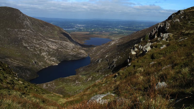
The spot where you are sitting was once at the centre of the super-continent of Pangea. A hot desert climate created the sands that, over eons, compacted to form red sandstone. Four hundred million years ago the sandstone was crumpled up by crustal plate movement to form the Armorican Fold Mountains of Munster. These immense movements would have been accompanied by volcanic activity.
Much of the rock between Mangerton and Beenaunmore to the east is rhyolite, a product of violent volcanic eruptions. And, of course, the final act in the drama which created the scene around you was the erosional power of moving ice. The boulder on which you are sitting was ripped from the mountain by this process.
The easiest way out of the glen is to ascend the steep slope behind you. A more interesting exit is to contour around the valley side along a narrow sheep track that brings you on to the arête which separates the Horses Glen from the Devil’s Punchbowl. Turn right up towards Mangerton North Peak and then down the heathery slope to rejoin the main path.
You can then head for the hostelries of Killarney and drown your insignificance in good company, food and drink.
THE HORSES GLEN
Co Kerry
Map Ordnance Survey Discovery Series, Sheet 78.
Start and finish A concrete bridge on the river Finnoulagh (grid reference 984 847)
How to get there Take the N71 Muckross Road from Killarney. Turn left at Muckross Park Hotel, then take first right. Apart from a small area by the bridge, parking is on the roadside
Time 4-5 hours
Distance 8km
Ascent 700m
Suitability Route is hard; full equipment essential
Food and accommodation Numerous choices in Killarney


