
This highly enjoyable walking route is the most fulfilling way to explore the unique natural attractions of the north Antrim coast. The 40,000 hexagonal columns of the Giant's Causeway form the most famous feature of the route, but the whole coastline is so striking you'll come away with countless other memories besides. The walk described here follows the best section of the two-day Causeway Coast Way. It starts at the thrilling Carrick-a-Rede rope bridge and traces the shoreline west past sandy beaches, secluded harbours, sheer cliffs and historic landmarks. Despite its linear format, return transport is not a problem.
The start and the finish points are linked via frequent buses – use the Ulsterbus Causeway Rambler shuttle service during the summer, and the Antrim Coaster service at other times of the year. The path is signed throughout, and frequent access points mean you can split it into sections to suit your own preferences. Note that the shoreline at either end of White Park Bay is impassable at high tide, so make sure to the check tide times before you set out. There's also a charge for visiting the rope bridge at the start of the walk and for entering the Giant's Causeway visitor centre at the end.
The Walk
If this is your first time visiting Carrick-a-Rede, a trip across the thrilling 20m-long rope bridge is highly recommended and will add 2km to the day. Pay your dues at the entrance kiosk and follow a well-benched path east from the car park. Few people make it across the chasm without a quickening of the pulse.
The island is particularly attractive in early summer, when puffins and gulls can be seen nesting on its cliffs. Return to the car park, then begin the route itself. Follow the path west along the clifftop, with Rathlin Island and Scotland's Mull of Kintyre both visible across the sea. When you join a minor road, turn right, descending to the quiet, picturesque harbour at Ballintoy. The road ends here, but the route continues west along a track, then a footpath.
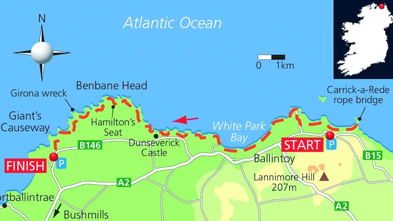
Pass a series of stacks and islands to reach the top of a stone beach. A brief boulder hop around the base of a cliff now brings you onto the 2km sweep of golden sand at White Park Bay. Cross the beach to the cliffs at its western end. Here you have to clamber across more boulders to reach Portbradden, an idyllic collection of houses fronted by a small harbour. St Gobban's Church lies beside the second house; it is no larger than a garden shed and holds the accolade of smallest church in Ireland. Continue through a natural rock arch and follow the path around Gid Point, crossing a mixture of rock and grass as you trace the indented coastline. Pass Dunseverick Harbour to reach The Sloc, a popular spot for swimming and rock jumping. Several more stiles then bring you to the ruins of 16th-century Dunseverick Castle. The grassy path continues north-west from here, climbing towards Benbane Head and Hamilton's Seat, the highest part of the route. You are now tracing the cliff line some 100m above the ocean and there are wonderful views west along the rugged coastline.
Midway between Hamilton's Seat and the Giant's Causeway you come to Plaskin Head. This marks the final resting place of the Girona, the most famous ship of the ill-fated Spanish Armada of 1588. It is not long now before you arrive at the Giant's Causeway. If you don't want to visit the site itself, continue along the cliff path to the visitor centre. Alternatively, a steep descent down the Shepherd's Steps will bring you to the basalt columns at the shore.
Legend dictates that the Irish giant Fionn MacCumhaill built the causeway as part of a bridge to Scotland, but scientists maintain that the hexagonal structures were created by cooling lava flows around 60 million years ago. To finish, follow the 1km tarmac driveway from the causeway to the visitor centre, which is situated at the top of the hill to the west.
Great for:
- Marvelling at unique geological formations
- Mixing fabulous coastal scenery with historic sites
Conditions:
- Calm or moderate winds and good visibility
Trip Details:
- Distance: 15km (9½ miles)
- Time: 5-6 hours
- Ascent: 200m (660ft)
- Maps: OSNI 1:25,000 Causeway Coast and Rathlin Island, or Glens of Antrim,
OSNI 1:50,000 sheet 5
Access:
To the start: The route starts at the parking area for Carrick-a-Rede rope bridge. This National Trust site is signed from the B12 just east of Ballintoy village.
- Grid Ref: D 052 448
- GPS: 55.238943, -6.347355
To the finish: The walk finishes at the car park for the Giant's Causeway. The causeway is well signed along the B146, around 3km north of Bushmills.
- Grid Ref: C 945 439
- GPS: 55.232943, -6.516253
An edited extract of one of 50 great activities in Ireland's Adventure Bucket List - Great Outdoor Experiences by Helen Fairbairn. Published by The Collins Press .
All photos by Gareth McCormack, garethmccormack.com


