
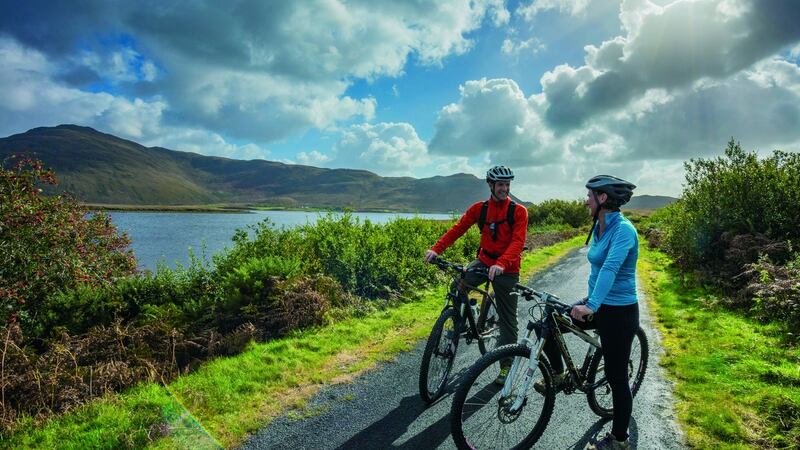
When it was completed in 2011, this wonderfully scenic route along the northern side of Clew Bay was the longest greenway in Ireland. It was an innovative project that proved so popular it inspired similar ventures all around the country. Today more than a quarter of a million people use the trail annually, all attracted by the well-benched, traffic-free track and consistently beautiful views over wild mountains, green pastures and Atlantic coastline.
The route follows the line of the old Midlands Great Western Railway, which closed in 1937. It can be completed in either direction, though the best approach is west to east, with the prevailing wind at your back. There are numerous access points, so it can be broken into smaller sections to suit your party.
The natural breaks come at Mulranny, after 13km, and Newport, after 31km. From Achill to Newport the scenery is consistently impressive, but many people choose to finish in Newport. The final section from here to Westport runs beside the main N59 road and is less attractive, and only really recommended for purists determined to complete the full route. The trail is fully signed and almost entirely off-road, with a surface of fine gravel as far as Newport, then tarmac beyond that. It's largely flat but does include a few gradual climbs, with several sharp ascents around Westport. There are numerous options for making detours or taking refreshment in nearby cafes, pubs and hotels. The open terrain ensures good views but also brings exposure to the elements, so make sure to dress appropriately.
Bike Hire
There are several bike hire outlets along the greenway, including Clew Bay Bike Hire (tel: 098 24818; clewbaybikehire.ie) and Greenway Bicycle Hire (tel: 086 0382 593; greenwaybicyclehire.com). Most companies offer bikes, baby trailers and child seats, as well as helmets and locks. Many have different outlets along the route, or provide shuttle bus services to bring you back to base. Expect to pay around €25 for an adult's bike or €15 for children, with a shuttle bus journey included.
The Ride
From Achill Island Hotel, follow the waymarks on to the main road and turn right. The first 800m follows the R319 road with no special provision for bikes, so care is needed here. The greenway then turns left up a short lane, and then sharp right onto the firm track that will continue for most of the rest of the day. The only interruptions come in the form of two or three gates and numerous cattle grids, which control access to the surrounding farmland. The gates require dismounting to negotiate while the grids can be ridden across with care. The scenery is immediately impressive, with just a few fields separating you from the shore of Blacksod Bay.
After 6km the trail sweeps south, and you pass Dánlann Yawl Art Gallery, which has an adjacent coffee shop and offers the first opportunity for a break. The scenery becomes wilder as you cross a sharp humpback bridge over the Cartron River and continue south-east across open moorland. The main focus of attention is now to the east, where the wild peaks of the Nephin Beg Mountains rise across Bellcragher Bay. Here you leave the Corraun Peninsula and join the mainland proper.
A long, steady climb through beautiful woodland brings you to a row of holiday homes beside Mulranny Park Hotel. Just beyond this lies the old Railway Station House, which has been renovated as a service centre for greenway users. Bike hire, toilets and showers are just some of the facilities on offer. Mulranny is a major access point for the trail; turn right beside the station house to reach the hotel and N59 road. If you want to add a detour of 2km, cross the road in front of the hotel, then carry the bikes down a flight of woodland steps. You can now cycle along a Victorian causeway spanning Trawoughter Bay, and enjoy a picnic at Mulranny's sandy beach. Return to the station house to resume your journey. Continuing east along the route, it's not long before you leave Mulranny and climb onto wild moorland on the lower slopes of the mountains.
The elevated position allows fabulous views over Clew Bay to the south. This wide Atlantic inlet is decorated by myriad islands, many of which are submerged drumlins left over from the last ice age. The unmistakable cone of Croagh Patrick rises skyward on the opposite shore. It's a beautiful vista, and one that stays with you for most of the way to Newport. Refreshment opportunities along this stretch include Nevin's Newfield Inn, reached via a detour to the right some 7km beyond Mulranny.
You now begin a long, gradual descent to the Burrishoole Channel, a tidal river. Pass through twisty red railings, then turn left over the distinctive Burrishoole Bridge, whose seven stone arches date from the 18th century. The route now crosses to the southern side of the N59. An optional, 1.5km detour to the right here brings you to the 15th-century ruins of Burrishoole Abbey, which is well worth investigating if you have the energy. The official trail runs beside the road for a kilometre, then joins the tarmac for the final approach. to Newport.
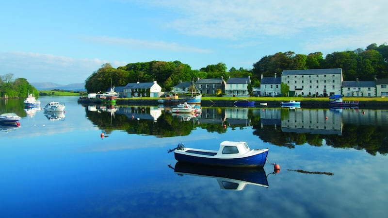
This small, attractive town has a wide selection of shops, pubs and cafés. If you’re continuing to Westport, cross the Black Oak River via the main road bridge. To the left you can’t miss the seven-arched viaduct built to carry the old railway across the water. The greenway follows the N59 out of town, then moves to a dedicated tarmac cycleway on the left side of the road. There are no services along this stretch, and the trail sticks close to the road for most of the way to Westport, with the exception of a short section in the middle. As you approach Westport, the greenway climbs gently through woodland and passes through a series of stone arches. You now join a private driveway and arrive at the Attireesh access point (grid ref: L 995 857).
The official route turns left here, climbs a very steep hill, then embarks on a rather convoluted and confusing loop around the eastern and southern side of the town, before finishing at Westport Quay. An easier option for reaching the quay is to turn right at Attireesh and follow this road to the N59. Cross straight over the N59, heading towards Carraholly. Roughly 500m later, then turn left into the northern entrance of Westport House. Follow this roadway through the park, past two minor junctions. Now turn right and left, heading towards the park's southern exit. This brings you over the Carrowbeg River to Westport Quay, with the large quayside car park located directly ahead.
Great for:
- Appreciating ever-changing views over wild mountain and coastline
- Whizzing across inhospitable bog with firm track beneath your wheels
Conditions: A dry day without too much wind
Trip Details:
- Distance: 42km (26 miles)
- Time: 4-5 hours
- Maps: OSi 1:50,000 sheets 30 and 31
Access:
- To the start: The greenway starts in the large car park for Achill Island Hotel/Óstán Oileán Acla. This is located beside the R319, at the mainland end of the bridge over Achill Sound.
- Grid Ref: L 740 999
- GPS: 53.933258, -9.919781
- To the finish: The best place to finish is Westport Quay, where vehicles can be left in a large quayside car park. The quay is signed along the R335 on the southwestern side of Westport town.
- Grid Ref: L 980 845
- GPS: 53.800223 -9.548640
An edited extract from 50 activities in Ireland's Adventure Bucket List - Great Outdoor Experiences by Helen Fairbairn. Published by The Collins Press/ collinspress.ie. All photos by Gareth McCormack


