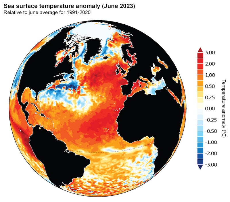
Heatwaves similar to those experienced off the west and north coasts of Ireland which saw sea surface temperatures jump by up to 5 degrees, are likely to become commonplace in a warming world.
Research led by Dr Gerard McCarthy of ICARUS in Maynooth University and a study by the UK Met Office come – boardly – to the same conclusions and warn of the likely strain marine heatwaves (MHWs) will have on marine ecosystems while also exacerbating extreme weather events in Europe
The June 2023 MHW, which affected the northwest European shelf, was unprecedented in terms of intensity and duration, the McCarthy study published by the Royal Meteorological Society finds. Scientists in France and Portugal contributed to the research.
The summer of 2023 was notable for a number of climate extremes: sea ice in the Antarctic dropped to its lowest for the time of year since satellite records began in the 1970s; terrestrial heatwaves engulfed southern Europe and southern US/Mexico that would have been “virtually impossible” without climate change, and sea-surface temperatures (SSTs) in the North Atlantic reached their highest since satellite records began in 1982.
READ MORE
[ Earth tips 2 degrees warmer in worrying milestoneOpens in new window ]
In concert with these terrestrial heatwaves and high Atlantic SSTs, a severe marine heatwave (MHW) developed in the eastern North Atlantic, west of Ireland, it confirms.
Except for a narrow band close to the coast from Greenland to Canada, SSTs everywhere in the North Atlantic were above the 41-year average (1982–2023), with many regions experiencing temperatures 2 degrees higher than average. In the study region west of Ireland, “the SST reached an impressive 4 degrees above average”.
A MHW is described as a discrete, prolonged (five days or longer), intensely warm water event. They have a direct impact on ocean ecosystems. Extreme heat can lead to widespread coral bleaching in shallow water corals, mass mortalities of marine species and marine deforestation.
In Irish waters, there is a recognition of the growing influence of warm water Lusitanian species over cold water boreal species, such as exemplified by growing numbers of anchovies off our coast.
The research shows a broad warming over the domain with maximum activity near the west coast with equivalent to temperatures of 2 degrees above average lasting for the full month of June. The heatwave was confined to a shallow layer, near the sea-surface. Settled conditions meant the normal mixing with colder deeper water did not occur.

Globally, MHWs have been increasing due to rising ocean temperatures. “However, since 2007, temperatures in Irish waters have been cooling linked by some authors to a decline in the Atlantic meridional overturning circulation, sometimes referred to as the Gulf Stream System,” it notes.
“The observed increase in MHWs in Irish waters presented here suggests that these waters are not immune from the effects of extreme ocean warming. It is unlikely that Irish waters will escape the forecast increased frequency of MHWs for the world’s oceans. In this context, the MHW of June 2023 could well be a warning for the future.”
The research from UK Met Office shows off the north of Ireland “anomalies” up to 5 degrees were recorded.
“With state-of-the-art observation and modelling capabilities, we show the MHW developed quickly in the first half of June due to strong atmospheric forcing (high level of sunshine, weak winds and waves, tropical air) during neap tides,” they conclude.
This shallow MHW then maintained itself by reducing cloud cover in persistent anticyclonic conditions, followed by another week of neap tides. A neap tide refers to a period of moderate tides, after a spring tide, when the sun and moon are at right angles to each other.
The MHW impacted the weather of northern Europe with stronger, warmer and moister sea breezes generating more rainfall and contributing to the breaking of June mean temperature records.


