
Local fire station officer Mark Sinclair summed up the impact of a month’s rain falling on Midleton, Co Cork, in a matter of hours during Storm Babet: “I think it was 11am that the river burst its banks, then by 2pm there was pure devastation. The main street was like a river.”
The toll was shocking. “It’s absolutely devastating. I’m born and bred in the town, I have seen many a flood, but none of this capacity. This came so quick, we helped as much as we could and tried to get as many people to safety as possible ... The town hasn’t seen anything like this in 400 years,” Sinclair said.
He identified factors that combined to make it so horrendous: recent heavy rain which saturated the ground, a high tide and torrential rain which led to the Owenacurra river bursting its banks. This is a typical scenario that can happen anywhere on Earth nowadays, where a trickle can suddenly become a mini tsunami overwhelming properties, sweeping up parked cars and wiping away roads.
[ Why was the Storm Babet flooding so bad?Opens in new window ]
Babet was a typical “extreme weather event”, likely to have been made worse by surging global temperatures being driven by man-induced carbon emissions. The scale of the adverse weather events this year alone has unnerved climate scientists.
READ MORE


While storms may be part of normal weather patterns, the climate factor is making them more frequent and more destructive, dumping more intensive rain in greater volumes as the planet heats up.
Ireland has had months of exceptional rainfall since late June and there is more “storminess”. Three ex-hurricanes landed this September. Research shows tropical cyclones are more likely to curve northwards when the tropical Atlantic is particularly warm, which is the case this year.
With extreme weather events, it is never just one thing. One additional contributor to turbulence is an atmospheric circulation pattern known as the North Atlantic Oscillation. This is “an index” reflecting the difference in pressure between low pressure anchored over Iceland and high pressure over the Azores. When the pressure difference is high, the westerly airflow over the Atlantic strengthens and a series of storms are directed over northern Europe.
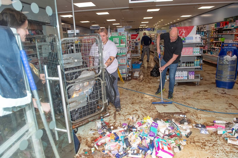
Europe has experienced many flash floods this year with little time for people and emergency services to take evasive action, as was the case in Cork and Waterford this week.
With many communities still dealing with the trauma of inundation on homes and businesses, it has prompted many questions: should Met Éireann have issued a red alert rather than an orange one? Is its colour-coded – yellow, orange and red – warnings on weather severity fit for purpose? What can be done to better prepare for such events?
Leading flood specialist Prof Conor Murphy of Maynooth University said the latest manifestation of flooding that hit the south coast flags an urgent need to improve forecasting around extreme amounts of rainfall.
This, he said, is a matter of “refining the scale”, by going beyond county scale to being better able to forecast what might happen in smaller local areas.
“This would be particularly useful for emergency response teams,” Prof Murphy said.
The warnings this week were for rainfall, yet the main impact was around flooding and previous rainfall leading to land saturation was not given sufficient weighting, Prof Murphy explained.
The circumstances underline the need to make a national flood warning service being developed by Met Éireann and the Office of Public Works operational as quickly as possible, he said.
This “most important adaptation tool” is being validated and will provide more time to make preparations. A revised national adaptation strategy is due by the end of the year.
Prof Murphy specialises in analysing temperature records going back centuries to determine when climate began to exacerbate weather. Research by his team, due to be published shortly, confirms east Cork is experiencing increased rainfall intensity due to climate change and temperature increases, particularly in summer and autumn, coinciding with exceptional ocean temperatures in the Atlantic.
This week’s events serve to underline the critical need for adaptation plans, which every local authority should have in place, he said. They serve to increase understanding of where they might be exposed to extreme weather events that are inevitable because of an overheating world, but also to identify who is vulnerable and what property might be at risk.
Allied to this, Prof Murphy said, there is much merit in investing in early warning systems including technology monitoring high water levels in river systems.
The extent of “climate shift” is the main factor in forcing a rethink by Met Éireann of its weather warnings, according to the national meteorological service’s chief forecaster Eoin Sherlock. The latest analysis of climate averages over a 30-year period since 1991 was as predicted but indicated the need for threshold adjustments, particularly on wind (which is stronger), and temperature with an increase of 0.7 of a degree corresponding to 7 per cent more rainfall.
At the launch of the State’s “Be Winter Ready” campaign this week, Sherlock admitted there are “too many yellow warnings” and it was working on ways to minimise them. He denied Met Éireann accepted that “warning fatigue” may be setting in with some members of the public.
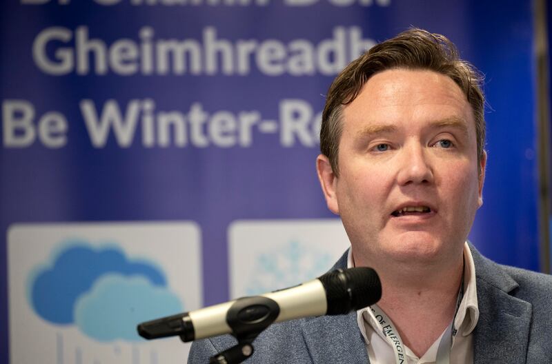
Speaking to The Irish Times, Sherlock acknowledged the risks of information overload post-Covid and of too much “cry wolf” but, in all instances, Met Éireann follows best international practice. There is a scientific basis for the thresholds, while it is ultimately up to the public to obey them. A yellow warning might be important to a painter-decorator working outside and “to everybody else it’s a soft day”.
Sherlock dismissed suggestions that in hindsight Met Éireann should have issued a red alert about Storm Babet, the orange alert was the correct one based on available data, forecasts and modelling for Ireland and Europe. There is only “one or two millimetres difference between an orange rainfall warning and a red”.
Increased amounts of thundery downpours is now a reality. While amounts of 30mm, 40mm or 50mm might be manageable over extended periods, “20mm in less than an hour can overwhelm drains”, Sherlock said. This is why Met Éireann is beginning to focus on hourly and three-hourly rainfall amounts and moving to impact-based warnings.
“We’re not going to tell you what the weather will be but what it will do,” Sherlock said, which may provide more wiggle room compared to the constricting thresholds of coloured warnings.
Long-term weather prediction is improving all the time “with better signals” along with capacity to analyse vast quantities of data, Sherlock said. Europe is developing a deep learning weather prediction system using artificial intelligence (AI) with a promise of even more accuracy.
Yet weather forecasts always come with a degree of uncertainty. If Storm Babet had shifted its trajectory by 150-170km it would have hit southern England instead, Sherlock said. There is much greater certainty around a high pressure system sitting on Ireland for a period compared with a rapidly developing low pressure system out in the Atlantic.