Ireland’s fascinating history is world-renowned, and its wealth of megalithic sites adds an element of majesty and mystery to its iconic landscape. While stones such as Newgrange and the other sites in the Boyne Valley are well known, the country abounds with beautiful megalithic sites, lesser-known but equally as interesting and accessible.
Starting in the southwestern counties of Cork and Kerry, there are a very large number of fascinating dolmens and stone circles, as well as stone rows and pairs of stones to explore, and many sites away from traditional tourist areas as well. Below is a small selection of the best sites to visit to discover Ireland’s old stones.
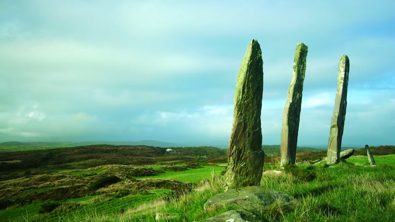
Gurranes Stone Row, Co Cork
Alt Name: Three Ladies
Townland: Gurranes
Map: W 1743 3152 | Sheet: D89 | Lat: 51.53082N | Long: 9.19054W
Three slender, finger-like pillars rising dramatically against the sky, with a fourth stone lying fallen nearby, out of line. The stones are impressively tall, the highest reaching 4.3m (14ft). Park near the church approximately 1.5km (1 mile) west of Castletownshend, walk 600m back towards the town, past the gate on the left, and follow the path to the stone row.
Cloghboola Beg Megalithic Complex, Co Cork
Townland: Cloghboola Beg | Nearest Town: Millstreet
Map: W 3054 8526 | Sheet: D79 | Lat: 52.01552N | Long: 9.01242W
On a platform of land at the head of the valley in Millstreet Country Park (south of Millstreet), the five-stone circle is just 3m (10ft) in diameter, with an unusual axial stone that's as tall as the portal stones. The complex also includes a well- preserved radial cairn or enclosure (with 19 stones standing), and there are also the possible remains of two stone rows. This site has the benefit of unrivalled access, including for wheelchair users.
Derreenataggart Stone Circle, Co Cork
Townland: Derreenataggart West | Nearest Village: Castletownbere
Map: V 6656 4629 | Sheet: D84 | Lat: 51.65385N | Long: 9.92894W
A charming axial stone circle with lovely views of the mountains and across to the sea. From the portal stones (one 2.4m/7ft 9in, the other broken), the stones decrease in height until the recumbent axial stone is reached, 1.2m (4ft) high and 2.2m (7ft 3in) long. Twelve stones of a probable 15 remain in the 8.5m (28ft) ring, of which three have fallen. Derreenataggart circle is unusual in that its axial stone is in the west, rather than in the southwest. The stones are visible from the road and there's a path for the short walk.
Axial stone circles had an odd number of stones - the axial stone is typically to the south west of the circle and usually the lowest and widest stone. The stones tend to increase in height as you go around the circle, to the tallest portal, or entrance stones to the north-east.
Archaeoastronomer Michael Wilson has analysed many stone circles in Cork and Kerry and proposed significant solar and lunar alignments for these sites. Similar circles can be found in North-East of Scotland, where they are known as recumbent stone circles.
Kenmare Stone Circle, Co Kerry
Nearest Town: Kenmare
Map: V 9068 7071 | Sheet: D85 | Lat: 51.87842N | Long: 9.58821W
Close to the centre of town, off Pound Lane, this is the largest circle in southwest Ireland. It is 17.4 × 15.8m (57 × 52ft) in diameter and has 15 stones, all smallish, rounded boulders. In the centre is a boulder burial with a massive capstone.
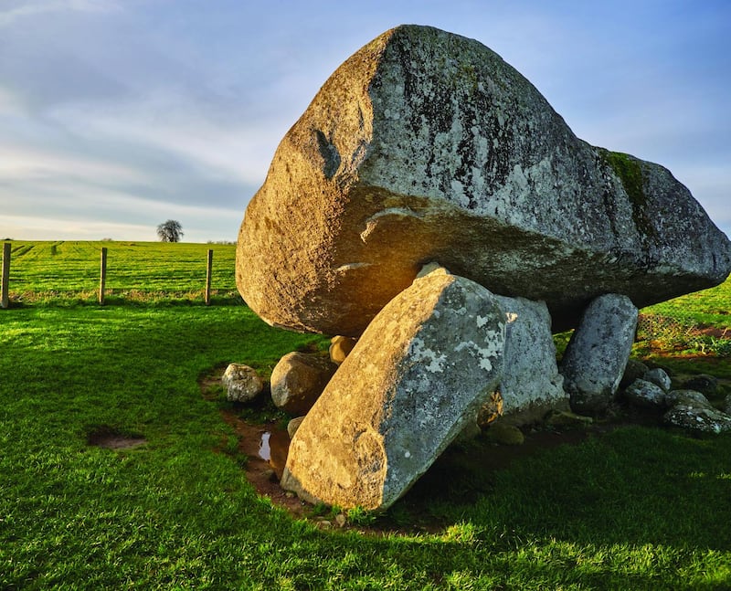
Browne's Hill Dolmen, Co Carlow
Alt Name: Dolmain Chnoc an Bhrunaigh
Townland: Kernanstown | Nearest Town: Carlow
Map: S 7538 7687 | Sheet: D61 | Lat: 52.837556N | Long: 6.881136W
An extremely impressive portal tomb with a truly enormous capstone, estimated to weigh over 100 tonnes, making it the largest stone ever used in a prehistoric monument in Britain or Ireland. Three stones – the two portals and the door stone - all around 1.8m (6ft), are still standing, supporting the capstone. Dolmens like this were built in the early Neolithic, from around 3500BC -their capstones are often much larger than would have been needed. Archaeologist Vicki Cummings has researched and excavated many dolmens in Ireland and Britain: "A capstone of this size was not required just as a "roof" for a chamber – why bother lifting a 100 tonne stone if it was just going to be covered up? These were monuments that were meant to be seen. Dolmens were like the cathedrals of the Neolithic – amazing constructions with great importance in people's belief systems."
Punchestown Standing Stone, Co. Kildare
Alt Name: The Long Stone
Nearest Townland: Punchestown | Nearest Village: Naas
Map: N 9173 1656 | Sheet: D55 | Lat: 53.19183N | Long: 6.62838W
An impressive standing stone that tapers to a sharp point. Found to be 7m (23ft) long when it fell in 1931, and re-erected in 1934, it now stands 6m (20ft) tall. An empty stone cist was discovered beside the original socket, which could not be preserved when the new socket was made.
Parknabinnia Wedge Tombs, Co Clare
Townland: Parknabinnia
Map: R 2648 9357 | Sheet: D51 | Lat: 52.98813N | Long: 9.09548W
Around 150 wedge tombs are known in County Clare, with over 70 of them concentrated on the upland limestone region known as the Burren (meaning "stony place"). Several can be found in the Parknabinnia heathland, as well as what appear to be partly worked capstones.
Parknabinnia 3 at R 2648 9357 is one of the more accessible tombs, close to a minor road leading off the R476. Recent excavations unearthed the skeletons of a child and an adult.
Close to Parknabinnia 1 are remains that look like abandoned workings, where large rough slabs – which abound in the area – were turned into capstones. Some unfinished stones seem to have been left propped up at one end in order to be worked on.

The Giant's Grave, Burren, Co Cavan
Wedge Tomb | Townland: Burren | Nearest Village: Blacklion
Map: H 0787 3523 | Sheet: D26 | Lat: 54.26589N | Long: 7.87990W
The Cavan Burren, like its Clare namesake, is a limestone region, considered one of the finest landscapes of its type in the country. Here, there are prehistoric field systems, glacial erratics and fossils, as well as a fine collection of wedge tombs. Walking trails in the Cavan Burren Park showcase a series of monuments, the most impressive being Giant's Leap wedge tomb, a very well-preserved example over 7m (23ft) long adjacent to the Giant's Leap gorge.
Nearby at H 0743 3526, 438m (1,437ft) west is the Tullygobban wedge tomb – ruinous but still impressive. The name is thought to derive from a tradition of attributing the building of such sites to the Gobán Saor, the master craftsman of Irish folklore. This is the closest site to the visitor centre.
Carrowmore Passage Graves, Co Sligo
Townland: Carrowmore | Nearest Town: Sligo
Map: G 6622 3371 | Sheet: D25 | Lat: 54.25112N | Long: 8.51904W
The tombs of Carrowmore are the earliest group of Irish passage tombs, with their chambers simply constructed out of large boulders. The people responsible for building them may have moved east, with monuments developing in sophistication as they went, culminating in the impressive cairns of Loughcrew and the Boyne valley. The Carrowmore monuments make up for their lack of sophistication by their huge variety and number, with around 30 still remaining out of more than double that number originally.
The majority of monuments are satellites of Tomb 51, also known as Listoghil. The tombs are known by the numbers 1-59, given to them in 1837 by George Petrie in a report for the Ordnance Survey. Site 7 and Site 5 are particularly photogenic, chunky dolmens, and Site 7 is also surrounded by a wonderful circle of 32 boulders. Sites 11, 26 and 57 are good examples of stone circles. Carrowmore is open from Easter to the end of October.