Estate agents selling desirable period homes in Clontarf or Sandymount may not wish to acknowledge it, but Dublin is among dozens of coastal cities worldwide in serious danger from rising sea levels driven by global warming.
The average mean sea level in Dublin Bay has risen by 120mm since 2000, according to Dublin City Council, or 7mm per annum, which is actually double the global average. Nobody knows if this is a temporary blip or a long-term trend.
“We are constantly monitoring sea levels in Dublin Bay,” the council says, while adding that “it is impossible to predict if this [rate of increase] will be sustained into the future as it may well be a local phenomenon of medium duration”.
As a rule of thumb, the council is working on the assumption that sea level in the bay will rise 500mm (half a metre) over the next 50 years, and that new flood defences now being installed “should cover us” for that extended period.
This may be wishful thinking, however, as the United Nations Intergovernmental Panel on Climate Change (IPCC) projects that sea levels will rise by at least 900mm and possibly as much as two metres between now and the year 2100.
The IPCC, with thousands of scientists worldwide contributing to its work, has based these estimates on the speed with which ice caps in the Arctic and Antarctic are melting, as well as rising ocean temperatures and continuing greenhouse gas emissions.
Higher increase
Impacts will not be felt equally throughout the world, with some coastal zones experiencing a higher increase in sea levels than others, depending on terrain, ocean currents, local hydrological conditions and other regional factors.
But there can be no doubt that Dublin is on the danger list. If the IPCC’s most pessimistic projection for sea-level rise turns out to be accurate, the impacts would be catastrophic for low-lying areas – without much stronger protection measures.
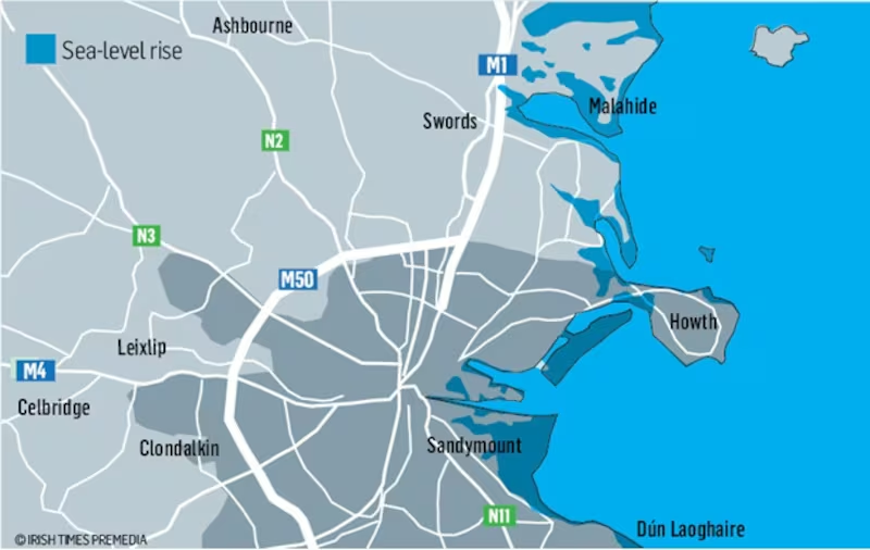
Dublin Bay is “highly vulnerable to marine inundation”, according to a summary of scientific research compiled by the State-sponsored Discovery Programme. “Virtually the entire coast from Rush to Bray could be affected by sea-level rise.
"Reclaimed lands around the north Dublin estuaries of Rogerstown, Malahide and Baldoyle, including lands designated for housing and recreational use, may become increasingly waterlogged," the report warned as long ago as 2000.
“The heavily developed area around Dublin Bay is vulnerable, especially from easterly winds and storm surges which may result in structural damage and flooding,” it said, adding that the city centre itself is located in the “major risk” zone.
It also found that boulder-clay cliffs between Killiney and Bray, and between Bray and Greystones, are "highly vulnerable", while low-lying land between Greystones and Wicklow is liable to flooding and retreat, threatening the Rosslare railway line.
Howth island
In a worst-case scenario, based on an extrapolation of geological data and the IPCC's most pessimistic projection, Howth could become an island (with Sutton wiped off the map) and Baldoyle a peninsula, while Bull Island could almost entirely disappear.
The Dart line between Merrion Gates and Monkstown has already been hit by periodic flooding. A 2015 report for Iarnród Éireann concluded that its current minimal coastal defences, which consist of only a wall in places, need upgrading.
How this is to be done is still an open question. Either it will proceed as a “standalone” project to protect Dart commuter rail services, or it could piggyback on the Sutton-to-Sandycove cycleway, which would involve building a long embankment.
If the capital is to be future-proofed, one of the ways to do it would involve constructing substantial marine “booms” in Dublin Bay to deflect or at least mitigate storm surges, as was proposed by a consultancy study several years ago.
But Dublin City Council, which commissioned the study, effectively downplayed this “vision”, saying the consultants involved had assumed a sea-level rise of 1.5m to 3m, “which on current evidence should not occur in the near future”.
The Irish Academy of Engineering, in its futuristic report Ireland in 2050, proposed a large sea dyke in Dublin Bay – topped by a motorway to "complete" the M50 – to prevent areas such as Clontarf and Sandymount disappearing under a 500mm rise in sea levels.
Barrage
What the council describes as a “very preliminary study” was also done on putting a barrage – similar to the Thames Barrier – between the North Bull and Poolbeg lighthouses, although the €1 billion estimate meant it was “not cost beneficial but may become so in the future”.
Not that any such barrage would do much to save Clontarf, Sandymount or other low-lying areas around Dublin Bay; it would merely protect the Docklands and the inner city. The Thames Barrier, on the other hand, safeguards most of London.
Designed to protect the city against storm surges and exceptionally high tides, the London barrier is now activated six or seven times per year – twice as often as it was in the 1980s – and it is expected to become less and less useful over time.
The devastating impact of storm surges was dramatically illustrated when Hurricane Sandy hit New York City in October 2012, killing more than 50 people and flooding parts of the subway network as well as road tunnels into Manhattan.
Since then, the city has developed a comprehensive “resilience plan” that identifies future flood zones and proposes a range of measures to protect them, including reinforcing beaches, building bulkheads and creating rock breakwaters offshore.
The costs of adaptation are estimated in billions of dollars, which is why New York filed a lawsuit seeking to recover damages from five major oil companies whose products are blamed for causing harm to the city; it was thrown out in July.
Boston also has a climate resilience initiative, Climate Ready Boston, which includes a continuous review of the scientific evidence, and its planning measures such as “deployable flood walls” to protect neighbourhoods most at risk of flooding.
Frontline
The US cities most vulnerable to sea-level rise are mostly located in Florida, with Miami in the frontline, even though its political leaders are in denial. Under the IPCC’s worst-case scenario, two million residents of Miami could be displaced.
Rotterdam, which is nearly all below sea level, was flooded in 1953, with the loss of 1,800 lives, and reinforced sea dykes were built to protect it. These are now being supplemented by “water plazas”, green walls and even floating neighbourhoods.
In Dublin, the city council is collaborating with the Office of Public Works (OPW) – the “national competent authority” in this area – on the provision of flood defence walls such as the new granite wall on George’s Quay or the jagged one on City Quay.
The OPW standard is a 1m increase in flood defences to protect critical infrastructure, such as hospitals, fire stations, old people’s homes, sewage treatment plants, power stations, etc – based on the IPCC’s low-to-medium projections.
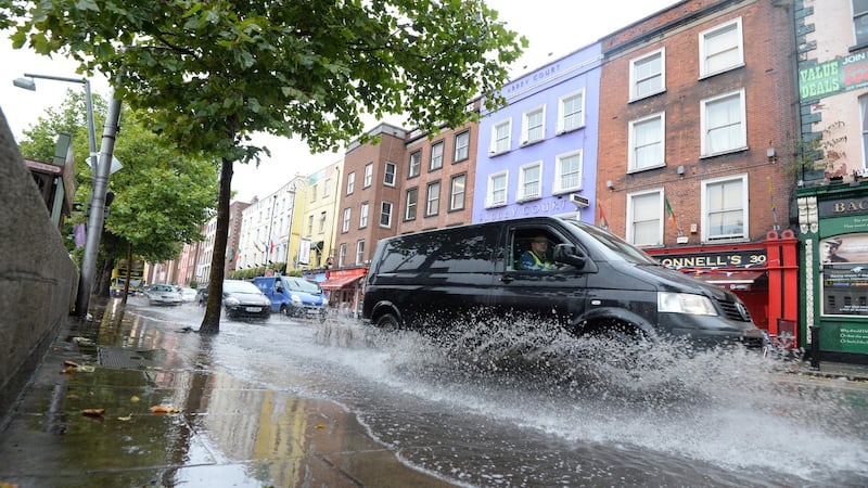
After severe flooding in Dublin in February 2002, caused by unusually high tides magnified by storm surges, the council put in place the Dublin Coastal Flooding Protection Project, which includes developing a coastal flood forecasting system.
“Currently, sea walls are being risen on a priority or opportunistic basis to protect as many buildings – mainly residential – as possible,” a council spokeswoman said. This “should cover us for at least 50 years of sea-level rise”, she added.
But building up sea walls can be very challenging, as shown by what happened in Clontarf, where pressure from outraged local residents seeking to protect views of Dublin Bay actually led to a long stretch of the newly-built wall being reduced in height by 300mm.
There has been less controversy in Sandymount over raising a sea wall by 360mm and installing floodgates along the promenade. A second phase of coastal protection works in the area will need to take account of the bay’s designation as an EU Special Area of Conservation.
Sooner or later, people living in low-lying areas around Dublin Bay will have to reconcile themselves to the creation of much larger structures – whether booms, breakwaters or sea dykes – if Ireland’s capital city is to be safeguarded against the worst impacts of climate breakdown.
Utilising the Liffey: an idea whose tide has come
Other cities with rivers running through the centre tend to make use of them. Dublin doesn’t, largely because the Liffey is tidal as far upstream as Islandbridge, with marked differences in water levels depending on whether the tide is in or out.
Apart from the annual Liffey Swim, some impromptu kayaking and the flat-bottomed boat that takes tourists on a trip to Docklands and back, the river is barely used at all. And yet it is unquestionably the city’s most important single feature.
Back in 1975, in Technology Ireland journal, a civil engineer called Conn Sheehan put forward a bold plan to create a barrage on the Liffey, east of Matt Talbot Bridge, so that the city stretch of it would be maintained at a constant level.
But his proposal "never received a fair hearing", as I noted in The Construction of Dublin. One former city councillor "strove in vain against obdurate minds for its adoption", but it was rejected by officialdom on the basis of "specious arguments".
Belfast completed the Lagan Weir in 1994 and, since then, the city stretch of the river is used by private boat clubs and a commercial river tour boat as well as the Lagan Watersports Centre, which runs sailing and canoeing on the river.
Dublin City Council should revisit the idea of constructing a weir or barrage, located at or near the East Link Bridge, to open up the Liffey to river traffic, including a boat service that could convey commuters from Heuston Station to Docklands.
At present, such a service is impossible due to the rise and fall of water levels on the tidal river. And whereas some people might miss the ebbing and flowing of Anna Livia, the benefits of bringing the river into use would be immeasurable.
EXPERT EVALUATION
Each of the proposals in this "Capital Ideas" series has been put to a group of three experts for an initial "back of an envelope" evaluation. They are: Frances Ruane, former director of the Economic and Social Research Institute; Caroline Spillane, director general of Engineers Ireland; and Cliff Taylor, Irish Times economics columnist.
Frances Ruane
This idea requires major capital investment. Its scale is huge but that should not stop the conversation being started immediately. This must involve a wide range of disciplines and not just engineers. External assistance from The Netherlands, which has 400 years plus of experience should be sought at the outset.
What will be important is for this to be a whole of city capital project, so that we get the best solution for the city and not just for flood management.
This should be one of the country’s major capital projects over the coming decades.
Caroline Spillane
In Engineers Ireland’s State of Ireland report this year, flooding received a C grade, meaning these sectors of infrastructure are inadequately maintained and/or unable to meet peak demand, and require significant investment.
Our organisation calls for holistic flood risk management for the protection of public health, critical infrastructure and the natural environment. This will require excellent and maintained flood defences and warning systems and sustainable land-use practices. Particular attention will need to be paid to measuring and designing for the effects of climate change and to the implementation of recently-published flood risk management plans.
The wider public must have a greater appreciation for the level of investment and structures required for flood risk management.
Cliff Taylor
Climate challenge is getting more serious and we need a strategic approach.
There are high costs here. Frank McDonald refers to the €1 billion estimate for a barrage in Dublin Bay, similar to the Thames Barrier. At a local level, the new Clontarf defences alone will cost an estimated €10 million, and government estimates have been that defences across the country could cost €1 billion. A recent UK study put the long-term cost of coastal defences at between £18 billion and £30 billion.
The key issue is planning, agreeing what level of climate change we need to play for and dealing with it on a planned basis. Like the cost of an ageing population, this has to be baked into the national figures.